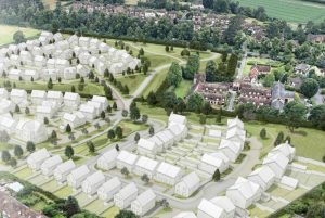
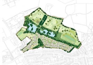
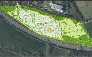
On 10th December 2024, the Full Council of Epsom and Ewell Borough Council convened to debate the proposed Local Plan, a pivotal document that will shape the borough’s future planning, housing, and Green Belt policies until 2040 and beyond. Central to the debate were contentious issues regarding housing targets, the timetable for the Local Plan submission, and the potential release of Green Belt land for development. The controversial Local Plan, including some Green Belt development, was voted through by 16 votes from a Council that consists of 35 Councillors.
Presentation of the Petition
The meeting began with the presentation of a petition organized by Yvonne Grunwald, titled “Remove Green Belt from the Epsom and Ewell Borough Council Local Plan.” Mrs. Greenwald argued the case against developing on Green Belt land:
“Over the last few years, residents have repeatedly told the Council that they do not want building on the Green Belt. They have held rallies, protests, they have spoken at council meetings. This includes secondary school children. They’ve sent emails to councillors and their MP… The results showed that 87% of respondents were opposed to building on the Green Belt.”
She criticized the council’s perceived disregard for public opinion:
“Why consult with the residents if you are going to ignore the result and actively undermine them?”
Mrs. Greenwald also pointed to an alternative plan that relied solely on brownfield sites:
“In November, opposition parties and the Green Party, together with residents, submitted an alternative plan, which showed that enough houses can be built on brownfield sites already identified by the Council.”
Concluding her speech, she urged the Council to act quickly to amend the plan:
“You must make sure that the Local Plan doesn’t include Green Belt… This should happen as quickly as possible so that it can be submitted to examination before the new NPPF rules come into force.”
Council Debate
Councilor Peter O’Donovan, (RA Ewell Court) Chair of the Licensing and Planning Policy Committee, responded to the petition. He acknowledged the concerns raised but defended the inclusion of Green Belt land in the Local Plan as a necessary compromise:
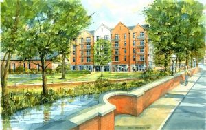
“The proposed submission plan… aims to strike the right balance of meeting development needs, including much-needed affordable housing, against protecting the borough’s Green Belt and character of the urban area, both of which are important to our residents.”
He warned of the risks of removing Green Belt sites from the plan:
“Officers consider that removing sites from the Local Plan would significantly increase the risk of the plan being found unsound at the examination stage. If our Local Plan is found to be unsound, we will have to restart the process again, meaning we will be without an up-to-date Local Plan for longer.”
Councillor Julie Morris (Lib Dem College) expressed her sympathy for the petition’s intentions but highlighted the challenges of late-stage changes:
“The problem with this petition is that it’s quite late in the day. Whilst I have every sympathy with its intentions and what it says, it’s actually quite difficult to implement that right now. You know, 12 months, 18 months ago, it would have been a different scenario.”
Councilor Bernie Muir (Conservative Horton) strongly opposed the inclusion of Green Belt land in the Local Plan, emphasizing the importance of protecting such spaces:
“Releasing high-quality Green Belt should be avoided at any time… Without this housing, our homeless levels will grow, not reduce. Releasing high-quality Green Belt without achieving a very significant benefit by doing so would be contrary to the NPPF and totally unacceptable.”
Councilor Clive Woodbridge (RA Ewell Village) cautioned against removing Green Belt sites, citing the experience of Elmbridge Council:
“Elmbridge… submitted a Local Plan with no Green Belt and a multiplicity of smaller brownfield sites. They are now faced with the option of either withdrawing it or having it found unsound. The inspector argued that the brownfield-only approach adopted would fail to deliver anything near the level of need for the planned period.”
Final Debate on the Draft Local Plan
When the draft Local Plan was introduced, Councillor Neil Dallen (RA Town) summarized the difficult position faced by the Council:
“Nobody wants to build on Green Belt, but there is not enough brownfield land. The risk is that this won’t be accepted, and we’ll be in even bigger trouble.”
Councillor Jan Mason (RA Ruxley) criticized the concentration of development in certain areas:
“You’re talking about the most densely populated part of this borough. This isn’t well thought out… There will only be harm.”
Councillor Chris Ames, (Labour Court) condemned the lack of affordable housing:
“This plan… will only deliver just over 1,000 affordable homes… fewer than 400 social rented homes by 2040. This is not sound.”
Clive Woodbridge defended the plan as a balanced approach:
“It delivers badly needed homes while protecting most of the Green Belt and maintaining the character of our borough.”
Outcome of the Vote
The Council ultimately voted on the draft Local Plan without amendments. The majority supported the plan, although several councillors abstained or voted against it. Councillor Peter O’Donovan’s remarks highlighted the Council’s predicament:
“This is the plan we have in front of us, and this is what we need to vote on today.”
Those opposing the plan, like Councillor Jan Mason, stood firm in their dissent:
“I’m personally against this plan… This isn’t something that will suit Ruxley and West Ewell.”
Conclusion
The Full Council’s debate underscored deep divisions over the Local Plan. While the plan’s supporters argued it represented a necessary compromise to meet government targets and protect the borough’s future, its critics condemned the perceived sacrifice of Green Belt land and insufficient affordable housing. The council’s approval of the draft plan marked a critical step forward, but the contention surrounding it suggests continued challenges as the plan progresses to examination.
The Voting: 16 FOR, 8 Against and 7 Abstentions.
Councillors Who Voted FOR:
- Arthur Abdulin, Residents’ Association, Town Ward
- Steve Bridger, Residents’ Association, Stamford Ward
- Neil Dallen, Residents’ Association, Town Ward
- Liz Frost, Residents’ Association, Woodcote and Langley Vale Ward
- Shanice Goldman, Residents’ Association, Nonsuch Ward
- Rachel King, Residents’ Association, Town Ward
- Robert Leach, Residents’ Association, Nonsuch Ward
- Steven McCormick, Residents’ Association, Woodcote and Langley Vale Ward
- Phil Neale, Residents’ Association, Cuddington Ward
- Peter O’Donovan, Residents’ Association, Ewell Court Ward
- Humphrey Reynolds, Residents’ Association, West Ewell Ward
- Alan Williamson, Residents’ Association, West Ewell Ward
- Clive Woodbridge, Residents’ Association, Ewell Village Ward
- John Beckett, Residents’ Association, Auriol Ward
- Hannah Dalton, Residents’ Association, Stoneleigh Ward
- Chris Watson, Residents’ Association, Ewell Court Ward
Councillors Who Voted AGAINST:
- Rob Geleit, Labour, Court Ward
- Christine Howells, Residents’ Association, Nonsuch Ward
- Alison Kelly, Liberal Democrat, Stamford Ward
- James Lawrence, Liberal Democrat, College Ward
- Bernie Muir, Conservative, Horton Ward
- Kieran Persand, Conservative, Horton Ward
- Julie Morris, Liberal Democrat, College Ward
- Jan Mason, Residents Association, Ruxley Ward
Councillors Who ABSTAINED:
- Chris Ames, Labour, Court Ward
- Kate Chinn, Labour, Court Ward
- Christine Cleveland, Residents’ Association, Ewell Village Ward
- Bernice Froud, Residents’ Association, Woodcote and Langley Vale Ward
- Tony Froud, Residents’ Association, Stoneleigh Ward
- Darren Talbot, Residents’ Association, Auriol Ward
- Graham Jones, Residents’ Association, Cuddington Ward
Procedural criticisms and more:
The Epsom Green Belt Group has raised significant concerns regarding the procedural handling of the Local Plan by the Residents Association-led council. They argue that the process lacked transparency and adequate opportunities for scrutiny.
In their press release, the Group stated:
“For almost two years, since the regulation 18 consultation in early 2023, the public has been waiting to see what would be included in the Local Plan, whilst lobbying for the protection of the Green Belt, submitting a 10,000-member petition, holding rallies and writing to councillors. Requests were made to discuss the Local Plan and the treatment of Green Belt in the fourth quarter of 2023, in July 2024, and in September 2024. Nothing was shared, and nothing debated until November 2024.”
This lack of earlier discussion and public involvement was also echoed during the Full Council meeting. Councillor James Lawrence (LibDem College) highlighted the limited opportunities for councillors to engage in substantive discussions:
“There have been cases where we could have been involved, such as after the briefings. There’s nothing wrong with having briefings, but those were never brought into the public domain until a few weeks ago.”
The Group also pointed to restrictions on questioning during the December 2024 Full Council meeting, which they argued severely limited proper scrutiny of the Local Plan. They noted that only five questions were permitted in total, with some councillors, such as Councillor Mason, restricted from raising further queries, and others, like Councillor Lawrence, unable to pose any additional questions. Councillor Mason’s frustration was evident:
“I had more to ask about the Green Belt allocations and the housing numbers, but I was told I had used up my chance. How is this adequate scrutiny for a plan that decides the future of this borough for 16 years?”
Additionally, the Group criticized the Residents Association for missing the opportunity to submit the Local Plan under the existing National Planning Policy Framework (NPPF) guidelines, which would have allowed for greater flexibility in protecting the Green Belt. They claim that the refusal to expedite the Local Plan’s preparation has exposed the borough to heightened housing targets under new rules.
Councillor Hannah Dalton (RA Stoneleigh) expressed the challenge of navigating a rapidly changing regulatory landscape but stopped short of endorsing the Group’s criticism of delays:
“We’ve got numbers that have changed. We’ve got new government ambitions. We want to build affordable and social housing. Whatever we do, it’s not going to satisfy everybody. That is the nature of Local Plans.”
The Group also accused the council of opening the floodgates for further Green Belt development by including high-quality Green Belt sites in the Local Plan. Councilor O’Donovan, however, defended the approach as a necessary trade-off:
“By including a small portion of Green Belt in the plan, we ensure protections for the rest. Without a Local Plan in place, developers will have greater freedom to target any Green Belt site.”