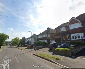
Affordable housing scheme approved on Leatherhead green belt
9 March 2026
Greenbelt land in north Leatherhead will be built on after a 100 per cent affordable housing estate was granted planning permission.
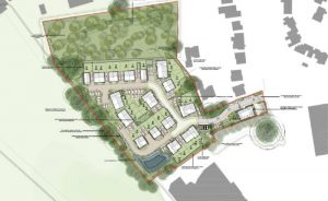
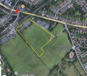
Mole Valley District Council’s development committee approved the proposals despite fears it could open the door to others looking to pick off valued sites. The 47 homes by developer Carmen Corp will be built in Oxshott Road, Leatherhead, next to the Tesco store after officers said the need for affordable housing outweighed damage done to green belt.
The site lies on rundown land near the M25 and its condition raised concerns with those opposed to development who argued it could encourage others to let greenbelt land fall into disuse to ease planning. Those in favour suggested the 47 affordable homes was too good to pass up – particularly as it was surrounded on three sides by development and currently looked like “no-man’s land”.
The plans were passed by seven votes in favour to four against.
Claire Malcomson (Liberal Democrat: Holmwoods and Beare Green) said: “Just because it’s degraded land is not a reason. We welcome affordable houses, we really don’t want people to think we don’t.
“This piece of land has been used badly for flytipping, and yes it would be wonderful if it hadn’t been. But I am concerned about this and I do feel that developers might be sort of almost trying to twist our arms just because it’s affordable.”
Others argued the site, derelict and surrounded on three sides, was exactly what was meant as grey belt. Its location next to a large Tesco store, as well as the affordable housing offer, meant the majority backed the plans.
The developer told the March 4 meeting the site suffered from historic misuse, flytipping and ecological decline – and highlighted the housing shortage in the borough. He also addressed questions on affordable housing, saying extra houses could only be occupied if they were made available at below market rates – such was the basis of Homes England funding.
Cllr Monica Weller (Liberal Democrats: Bookham West) said: “We need to be honest about what this site actually is now. Is this pristine, untouchable countryside or is it more, I hate to say, a wasteland?
“I felt that I was going into no-man’s land. Let’s not joke or kid ourselves that this is special, this is rough. And affordable housing is one of the biggest issues facing families.”
Plans for Oxshott Road near Leatherhead (image MVDC)
Fresh Local Plan row as councillor questions Green Belt revisions and governance at Epsom and Ewell
9 March 2026
Concerns are growing over Epsom and Ewell Borough Council’s Local Plan after campaigners and a borough councillor raised questions about revised evidence submitted to the Government Planning Inspector — including whether key changes were made without councillor oversight.
The controversy centres on documents submitted during the independent examination of the borough’s Local Plan, which will determine where housing development can take place for years to come.
A Green Belt campaign group, a planning expert and Conservative councillor Kieran Persand have all raised concerns about revisions to the evidence base — particularly a Green Belt Topic Paper which could influence whether some land currently protected as Green Belt is opened for development.
Campaigners question governance of revisions
The issue first surfaced in a widely circulated email from the Epsom Greenbelt Group to borough councillors warning of “urgent and serious concerns regarding the recently submitted revised Local Plan documents and the process by which they appear to have been approved and issued.”
Campaigners argue that councillors previously authorised officers only to make minor corrections to documents submitted to the Planning Inspector — not material revisions to the evidence.
They say that if significant changes were submitted without member oversight it would raise serious governance concerns and undermine democratic accountability.
The group has called on councillors to clarify what authority officers relied upon when submitting revised documents and whether the Council’s Monitoring Officer has reviewed the matter.
Expert analysis identifies potential Green Belt changes
Planning expert Tim Murphy has reviewed the Council’s January 2026 Green Belt Topic Paper and identified 33 Green Belt sites assessed for their contribution to preventing urban sprawl and protecting countryside.
Mr Murphy said several sites which scored relatively highly under the Council’s own Green Belt rating system were nevertheless recommended for boundary changes that could allow development.
The sites highlighted include:
Land north of College Road at Downs Farm
Land near Ewell East Station
Land west of Burgh Heath Road near South Hatch Stables
Land extending the Noble Park estate within the Hospital Cluster
Mr Murphy said the justification offered was the existence of “exceptional circumstances”, but added that he did not find the arguments convincing.
He noted that these sites have ratings comparable to Horton Farm and the Hook Road Arena — two locations which generated significant public opposition during Local Plan hearings last year.
Other Green Belt sites treated differently
Mr Murphy also pointed out that other Green Belt locations with similar ratings are not recommended for boundary changes, including:
Hollywood Lodge
Drift Bridge Farm
Land off Banstead Road
Land east of Burgh Heath Road
Several smaller sites near Downs Road
The difference in treatment raises questions about consistency in the assessment process.
Meanwhile, a separate planning application for 110 homes at Langley Vale — on land not recommended for Green Belt boundary change — was recently rejected by councillors by six votes to two.
Councillor calls for urgent review
The debate intensified this week when Horton ward Conservative councillor Kieran Persand wrote to the chair of the Council’s Local Plan Policy Committee (LPPC) urging urgent action.
In his email to councillors, Persand said he had become aware that revised evidence had been sent to the Planning Inspector which “materially differs from evidence previously submitted,” including a document known as COUD_021.
He said the document appeared to have been submitted without review or approval by the LPPC, the committee responsible for overseeing the Local Plan.
Persand wrote that he had already identified “important errors and other concerns” in the document which he believed should have been addressed before submission.
He also said he had been unable to find any significant change in circumstances — such as changes in national policy — that would justify altering the conclusions of the borough’s earlier Green Belt assessment.
Further Green Belt additions possible
Persand warned that the situation may be evolving further.
According to correspondence with the Planning Inspector cited in his email, council officers indicated that additional evidence and amendments could be submitted by 6 March, potentially including recommendations for further Green Belt sites to be added to the Local Plan.
Persand noted that there were no Local Plan Policy Committee or full council meetings scheduled before that date.
“This suggests that the officers’ amendments to submission documents, and proposals for changes to the Local Plan they plan to submit on 6 March, will also not be subject to any review or approval by the LPPC or Full Council,” he wrote.
He warned that proceeding without councillor oversight could expose the council to accusations of failing in its duties and even potential judicial review.
Call for documents to return to councillors
Persand has asked the committee chair to arrange for all evidence documents submitted to the Inspector to be brought before the Local Plan Policy Committee before any further submission.
He acknowledged that doing so could delay the council’s proposed timetable but argued this would be preferable to risking more serious problems later in the process.
Questions to the council remain unanswered
The Epsom and Ewell Times contacted the council’s communications department on 28 February seeking clarification on the situation.
The newspaper asked whether a revised paper recommending the removal of some sites from Green Belt protection had been submitted to the Planning Inspector.
At the time of publication, no response had been received.
What happens next
The Planning Inspector will ultimately decide whether the borough’s Local Plan is “sound” and can proceed.
However, the council itself remains responsible for setting the borough’s strategic direction.
If significant changes to the evidence base are confirmed, councillors may face renewed debate over housing numbers, Green Belt protection and how the Local Plan examination is being managed.
The outcome could shape where thousands of new homes are built in the borough — and whether parts of its Green Belt remain protected — for decades to come.
Ewell’s Looe Set for Flush of New Industrial Investment
9 March 2026
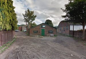
An ageing industrial site in Ewell is set for a major overhaul after councillors backed plans to knock it down and rebuild it with bigger, more modern units.
The scheme at The Looe, off Reigate Road in Nonsuch, will see 17 tired single-storey units demolished and replaced with a new part one, part two-storey building containing nine industrial and business units. Councillors green-lit the plans at an Epsom and Ewell Borough Council planning committee on February 26.
Cllr Phil Neale (RA Cuddington) said: “I think it is going to be a vast improvement. I have had a look at the current site and it’s not one of our most attractive industrial units at the moment.”
There will be fewer units overall (nine instead of 17) but they will be larger, creating more workspace. The total floorspace will jump from 732sqm to just over 1,200sqm.
The new building will mainly cater for industrial and storage businesses. Plans include:
One commercial unit (such as a shop or service business)
Four general industrial units
Four storage and distribution units
16 car parking spaces
18 cycle spaces
Solar panels on the roof
A small security and plant hut
There will also be a new pedestrian refuge crossing on Reigate Road and a segregated footpath along the access road to improve safety for people walking to and from the site.
Planning officers said the land counted as previously developed ‘grey belt’ land, meaning the redevelopment is not considered inappropriate under national planning rules. The developers have also promised a new planting and habitat improvements to the site, over and above the council’s requirement.
Less office space, more industry
The plans will reduce the amount of office space on the site. But council officers said there is enough office capacity elsewhere in the borough, particularly in Epsom town centre and East Street, to absorb the loss. At the same time, the borough has a shortage of industrial and storage space so the new scheme could help meet demand.
Traffic worries raised
Three neighbours objected, raising concerns about large lorries struggling to access the narrow entrance road, vehicles blocking Reigate Road while waiting to enter, sewage capacity and asbestos removal. Concerns about shared boundary walls were deemed a civil matter, and asbestos removal would be handled under separate legislation.
Highways officers said the development would generate slightly more traffic than the current site, but not enough to cause a “severe” impact on the local road network. The new footpath and crossing were described as public benefits.
The Looe, Reigate Road, Ewell. (Credit: Google Street View)
Horses beat cars in Epsom’s Langley Vale housing development application
9 March 2026
Plans to build up to 110 homes on agricultural fields in Epsom have been thrown out with fears of a horse vs car ‘collision corridor’. The Langley Vale scheme has been rejected following fierce objections from councillors, local campaigners, and the Jockey Club.
The proposed site, just a stone’s throw from the world-famous Epsom Downs Racecourse, was described as “unsustainable” and a threat to both local wildlife and the town’s horse racing heritage.
After a heated debate at Epsom and Ewell Borough Council’s planning committee on February 26, councillors shot down the application. Reasons for refusal included the site’s poor transport links, reliance on private cars, harm to the openness of the green belt, risks to horses and riders, and adverse effects on the landscape.
Cllr Jan Mason (RA Ruxley) did not mince her words. “It’s not just a few extra cars,” she said. “Have we actually raised the issue of the Jockey Club? The most famous race in the world is held in Epsom in June and has gone on for probably 300 years. This company is only after money.”
She also highlighted the practical issues for new residents: “If there’s no school nearby, no shops, no bus service, then sticking families up on the downs isn’t giving them a home. It’s dumping them where nothing exists.”
Highways and transport were another huge concern. Cllr Steven McCormick (RA Woodcote and Langley), who represents the area, called the application “fundamentally and legally unsafe,” citing the risk to both residents and the racing industry. “Records reveal a terrifying reality when a horse spooks, its instinct is to bolt for home, often forcing these 500 kg animals onto the public road network” he warned. “By placing 110 homes and hundreds of daily car movements at the mouth of the Warren, a known site for unseated riders, we are creating a collision corridor.”
Local campaigners echoed those concerns. John Mumford, speaking for the Langley Vale Action Group, noted the overwhelming public opposition of 374 letters of objection and a petition with 2,232 signatures. He said: “ For every reason put forward to justify the scheme, there are more compelling policy and environmental reasons as to why this scheme should be refused.”
Bernice Froud (RA Woodcote and Langley), another councillor, painted a vivid picture of the community at risk. “You cannot mitigate the destruction of a community’s soul.” She pointed to horses being part of Epsom’s heritage amongst other wildlife. “The rare and beautiful plant, the night flowering catchfly, has chosen our village as its home. Once we pour concrete over it, we will destroy this site of nature conservation importance forever.”
The Jockey Club added weight to the case, stressing that Epsom’s horse racing industry generates over £63m a year and that the development would “have a significant adverse impact” on operations and equestrian safety, including routes used by racehorses to reach training grounds.
While councillors agreed homes, especially affordable ones, are sorely needed, it does not come at any cost.
Image: View of proposed Langley Vale development. (Credit: Fairfax Aspire Ltd/ Epsom and Ewell Borough Council planning documents)
The Ripley effect of rural development in Surrey
9 March 2026
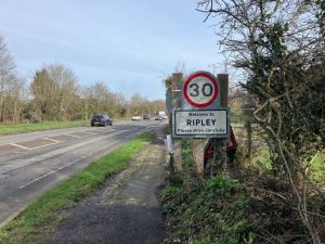
Surrey villagers say they fear their semi-rural community will be “overwhelmed” by development.
Ripley is frequently named one of the prettiest and best places to live in Surrey. But locals are worried it could soon lose the charming character that drew them there as plans for up to 540 homes on farmland edge closer to submission.
The proposed development of Grove Heath North, between Ripley and Send, would see hundreds of two- and three-storey houses built on farmland off Portsmouth Road. While the scheme is still at the environmental scoping stage, locals say the scale alone is enough to change the face of the historic village for good.
‘Completely out of character’
Brian Crosby, chairman of the Grove Heath North Residents’ Association, moved to Ripley 33 years ago from Twickenham for what he calls its “semi-rural character”.
Brian said: “We want to maintain the identity of villages at the edge of the countryside. This [development] just doesn’t sit comfortably behind the existing houses. It would virtually join Ripley to Send Marsh creating more urban sprawl.”
He described the proposal as a major speculative development that is not currently identified as a potential development site in the Local Plan and is a complete shock to our residents who are in disbelief, adding: “The developers do not care what happens to the village afterwards.”
To add insult to injury, the scheme also borrows the very name of Brian’s road, Grove Heath North, which is almost opposite the site. He said he has raised the issue with the developer, arguing it will be confusing for emergency vehicles or delivery drivers in future.
Residents are particularly concerned about three-storey homes, which they say would be “completely out of character” in a village proud of its heritage and historic High Street, once known as the first stop on the coaching route to Portsmouth from the 16th century. The Allium Park Development a mile up the road has 3 storey building being built and these are completely out of character.
While Brian accepts more homes are needed, he argues they should not be built on greenbelt farmland. “This is the easy option,” he said. “The land is used for agriculture. Don’t we need more farmers and people producing food for our country?”
Plans include a new village green, a nature trail and suggests a new local shop. However, the application does not clarify if the developers would build it and the new store would be located next to an existing farm shop.
But Brian said it felt like it was part of a tick-box exercise. “Ripley has one of the largest village greens in the country,” he said. “Giving us effectively what we have already got isn’t adding anything. Sally added the proposed site already had public right of way footpaths running across it.
The developer response
A Green Kite Homes spokesperson said: “This site presents an opportunity to deliver a landscape-led development of new homes and community uses in a highly sustainable location. Our proposals would address identified local housing needs, delivering homes in a range of sizes and tenures.
“We have also listened carefully to feedback received during the public consultation and, as a result, have decided to change the name previously used for the site. We will be engaging further with the local parish councils on this.”
Fears over traffic, schools and sewage
Brian and fellow resident Sally pointed to other large schemes in the wider area, including Wisley Airfield (around 2,000 homes), Gosden Hill (1800 homes), Send Marsh (140 homes) and Allium Park (around 620). They argued there is no “joined-up thinking” about the cumulative impact on roads, schools, doctors and drainage.
Sewage capacity has sparked particular anger. Brian claimed the local works are already struggling and have discharged into the River Wey during heavy rainfall in the last few weeks. They pointed to comments from Thames Water indicating major upgrades are not due to be completed until 2030 and Ripley Sewage plant would not be able to meet Government targets for storm overflows until 2045-2050, and questions whether new homes should be occupied before then.
They questioned the pressure on already stretched services. Brian and Sally warned there is only one GP surgery in neighbouring Send which serves both Ripley and Send and one private dentist in Ripley. “The surgery has already had to increase patient numbers and cannot physically increase further,” they said. “Where are all these people going to go?”
There are also claims the local primary school is oversubscribed and there are no local secondary schools nearby, and fears that hundreds of additional commuters would pile a “burden of traffic”. They said roads are already busy, with effectively one main route running through the village, which is often used as a cut-through despite the A3 bypass since there aren’t on and off connections to the A3 at each end of the village.”
A Green Kite Homes spokesperson said: “As part of the planning process, we will continue to work closely with the council and statutory consultees to ensure that local infrastructure can appropriately support development of this scale. This will also include financial contributions towards infrastructure upgrades as part of any future planning consent for the site.”
The current submission is only about setting the scope of environmental studies, not approving the homes themselves. Guildford Borough Council’s decision on the EIA will determine what issues must be examined in detail before any full planning application is considered.
Stoneleigh & Auriol Voters Back Neighbourhood Plan – But What Will It Change?
9 March 2026
Residents of Stoneleigh and Auriol have decisively backed their Neighbourhood Plan in a local referendum, giving it formal authority to influence planning decisions in the area until 2039.
At the poll held on 12 February 2026, 1,296 voters supported the plan, with 92 voting against. Turnout was 20.7% of the 6,724 electorate, with just one ballot paper rejected.
Voters were asked whether Epsom & Ewell Borough Council should use the Neighbourhood Plan to help decide planning applications in the neighbourhood area.
The Council has confirmed that the next step is for the Licensing and Planning Policy Committee formally to “make” (adopt) the plan, after which its policies will be used in determining planning applications in Stoneleigh and Auriol.
What the Plan Covers
The Stoneleigh and Auriol Neighbourhood Plan (SANP) covers around 180 hectares broadly aligned with the two wards and runs to 2039.
Prepared by the Stoneleigh and Auriol Neighbourhood Forum, the plan’s stated vision is to retain the area’s “unique character and strong sense of community” while allowing it to grow to meet future needs.
Once made, it becomes part of the statutory development plan and must be used in deciding planning applications, alongside the Borough Local Plan and national planning policy.
Core Principles in the Plan
The plan does not allocate major development sites. Instead, it focuses on design control, protection of character, safeguarding retail and community facilities, environmental sustainability and parking standards.
Housing and design: New development must maintain consistent building lines and complement existing form, massing and roofscapes, reflecting the area’s largely 1930s suburban layout. Development should generally respect the prevailing two to three storey character, using materials sympathetic to the area. Backland development may be permitted only where access, amenity space and privacy standards are satisfied. The Forum supports higher-density development where it is demonstrably sympathetic and does not harm local character.
Retail and community facilities: Proposals that enhance local retail facilities will be supported, while changes of use that threaten the predominance of commercial uses in retail centres will be resisted.
Green spaces and environment: The plan designates and protects local green spaces, seeks to minimise flood risk and supports renewable energy and energy efficiency measures where compatible with local character.
Transport and parking: Development must assess transport impact and provide adequate residential parking and cycle storage.
What Is Its Legal Weight?
Neighbourhood Plans derive their authority from national planning legislation. Once formally “made”, they form part of the statutory development plan.
Planning applications must be determined in accordance with the development plan unless material considerations indicate otherwise. In practical terms, SANP policies will therefore carry weight in planning decisions and appeals.
However, they must be in general conformity with strategic policies in the Borough’s Local Plan and with national planning policy. They cannot override housing targets or contradict higher-level planning frameworks.
Does It Add Anything New?
The referendum result gives the plan a strong democratic mandate. Yet a legitimate question arises: does the Neighbourhood Plan introduce new planning principles, or does it largely restate existing ones?
Many of its core themes — protecting local character, limiting excessive height, maintaining building lines, safeguarding retail centres, supporting sustainable drainage and requiring parking provision — are already embedded in the National Planning Policy Framework, existing Borough Core Strategy and Development Management Policies, and established appeal decisions emphasising design quality and character.
The plan does not set housing numbers, allocate strategic sites or alter Borough-wide growth targets.
Its practical effect may therefore be less about introducing new rules and more about giving locally specific design guidance additional statutory status, strengthening the weight attached to character arguments at appeal, and sending a clear political signal about community expectations.
Whether that materially alters planning outcomes will be tested in future applications and appeals.
What Happens After April 2027?
The abolition of Epsom & Ewell Borough Council in April 2027 and its confirmed replacement by the East Surrey Unitary Authority will not invalidate the Neighbourhood Plan.
Neighbourhood Plans form part of the statutory development plan for the land area, not merely for the council that adopted them. The East Surrey Unitary Authority will inherit responsibility for applying the SANP in determining planning applications within Stoneleigh and Auriol.
However, the new authority will prepare its own strategic development plan covering a much wider geography. Over time, neighbourhood plan policies can be superseded or carry reduced weight if inconsistent with new strategic frameworks. The Neighbourhood Forum will also require renewed designation if the plan is to be formally reviewed or updated.
In short, the SANP is likely to survive reorganisation — but its long-term influence will depend on how it aligns with the policies of the incoming East Surrey authority.
A Strong ‘Yes’ — and a Test Ahead
With more than 93% of votes cast in favour, residents have clearly expressed a wish to shape development in their area.
The real question now is whether the Neighbourhood Plan will meaningfully change planning outcomes — or whether it primarily codifies principles already embedded in existing local and national policy.
That answer will emerge not at the ballot box, but in the planning committee room — and, potentially, on appeal.
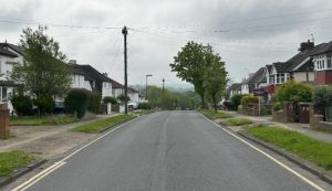
Image: Typical Stoneleigh residential road. Google Street View
Cllr prays for Priest Hill not to be developed in Ewell
9 March 2026
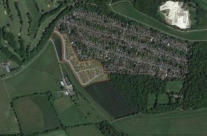
A controversial proposal to build hundreds of homes on Green Belt land at Priest Hill in Ewell has re-emerged, with developers now progressing a revised scheme for up to 300 homes. The land, adjacent to Ewell East Station, had previously been identified in the draft Local Plan as a major housing allocation but was later removed from the Regulation 19 version due to concerns over deliverability.
From 350 Homes to 300
Under the earlier Regulation 18 Draft Local Plan, the site — known as NON013 — was allocated for at least 350 net zero carbon dwellings, with buildings up to six storeys, ground-floor retail space and the re-provision of playing pitches at Hook Road Arena. However, concerns were raised during consultation. Sutton & Epsom Rugby Football Club (RFC), which leases part of the site until 2079, objected strongly, citing the importance of its pitches to its 2,000 members and warning of potential harm to its long-term viability. Sport England also raised concerns, noting that any loss of playing field land would have to meet strict national policy tests, including equivalent replacement in quality, quantity, location and accessibility. Following these issues, and in the absence of evidence that long leases could be surrendered, the Council removed the site from the Regulation 19 Proposed Submission Local Plan in November 2024.
What Has Changed?
According to the Council’s latest position statement dated 22 January 2026, the landowner’s agents are now seeking pre-application advice for a revised scheme. The updated proposal would redevelop approximately 4.9 hectares currently under the leasehold control of Old Suttonians for up to 300 homes, while retaining the 3.7 hectares leased to Sutton & Epsom RFC as sports pitches. Old Suttonians confirmed to the Council in December 2025 that their use of the land for sports ceased in 1999, the clubhouse and changing rooms were demolished in 2015, and they have signed an option agreement to return their land to the freeholder for redevelopment. They do not sub-lease or share the land with other parties. In contrast, Sutton & Epsom RFC confirmed in January 2026 that it fully utilises its leased land for three senior pitches and one mini pitch and has no intention of ending its lease early, with 53 years remaining.
Green Belt Concerns
Nonsuch Ward Conservative councillor Shanice Goldman has called for urgent clarity over the revived proposals. The site lies within the Green Belt and while the revised scheme indicates that rugby pitches would remain, residential development would still take place on designated Green Belt land. Cllr Goldman said: “The protection of Green Belt and transparency in process are not optional extras. They are fundamental.” She added: “This is still Green Belt land. And once Green Belt is gone, it does not come back.” Residents, she said, had been left with the impression that large-scale development at Priest Hill was no longer proceeding and were now asking what has changed.
Housing Need Versus Open Land
The landowner’s agents have previously argued that the site is well served by public transport and should be reconsidered given the borough’s unmet housing need. The current proposal is at pre-application stage, meaning no formal planning application has yet been submitted. However, the renewed activity is likely to reignite debate over housing numbers, Green Belt protection and the future of community sports provision in Ewell. Interested parties include Epsom & Ewell Borough Council, the freeholder Coldunell Limited, Old Suttonians and Sutton & Epsom Rugby Football Club. Further details are expected once a formal planning application is lodged.
Image: Development area approximately overlaid on Google Map aerial view of Priest Hill.
.
.
.
.
Council didn’t stand up Dorking Wanderers
9 March 2026
A new spectator stand that will “support the continued success” of Dorking Wanderers Football Club can stay after the club secured planning permission.
The Mole Valley club had already erected the four-row seating section in the northern corner of its Meadowbank Ground in Dorking, and it has been used since April 2025, giving spectators a better view of games. The planning application was submitted retrospectively and was granted at the February Development Management Committee meeting of Mole Valley District Council.
The tiered 100-seater stand will not increase the club’s overall capacity of 4,121, but will instead upgrade facilities for supporters who had previously been required to stand pitch-side. Objectors raised concerns about the potential for increased noise and disturbance, but planning officers said an October 2025 site visit found that existing sound-damping fencing and newly planted trees would mitigate such issues, and that the stand would not affect maximum attendances.
Mole Valley’s environmental health team said the stand would result in a negligible increase and no material change in terms of noise impacts on match days. Officers told the meeting that the new stand, which can be folded away as required, “would not increase spectator numbers, though the arrangements for spectators would differ to the current arrangement, with the three-tier seating area instead of ground-level standing.”
She added that the stand would enhance facilities at the established community ground and support the continued success of Dorking Wanderers. The application was approved without opposition after councillors were told the stand was already in place and that all objections raised had been addressed.
The approval follows a number of upgrades to the ground in recent years, including a new part-covered terrace at the western end approved in 2022, alongside LED floodlighting, additional turnstiles, TV facilities and an expanded fan zone. The western terrace was constructed after the club’s promotion to the National League in order to meet entry requirements.
Red rag at Bull Hill as residents rage over high-rise plans
9 March 2026
Huge high rises including hundreds of homes near a small Leatherhead park will kill the town and plunge precious playspace into shadow, say campaigners fighting the plans.
Mole Valley District Council has formed a partnership with Kier Property to “transform Leatherhead” by delivering new housing and upgrading the dated 1980s Swan Centre shopping precinct.
The original plan split housing between Bull Hill open space next to the railway station and the Swan Centre. However, engineers later advised that the shopping centre could not support housing, prompting a late change that would place all 480 homes, offices and a multi-storey car park on the Bull Hill site.
Campaigners say the height of the buildings would cast much of the remaining open space and children’s playground into shade and turn a designated safe walking route for school pupils into an access road for construction workers. They say the proposals would dwarf the existing three-storey blocks near the park.
Residents say they are not opposed to housing and understand the need for town-centre development to protect the wider green belt, but argue that the scale and intensity of the proposals are too much for Leatherhead to absorb. Speaking to the Local Democracy Reporting Service, they said the project alone would increase the town’s population by almost 10 per cent and permanently alter its character.
The council argues the homes will help meet housing targets, fund the regeneration of the Swan Centre and protect valued green space outside urban areas. It also says the project would create jobs, increase footfall for shops and include a new three-screen cinema as part of a £12m refurbishment of the centre — a figure residents compare with the £14m agreed to refurbish Dorking Halls without building on open space.
Campaigners’ concerns
Steve Preston, Susan Hood and Bev Emms have led opposition to the proposals, organising resident meetings and encouraging people to submit views to the council, whether in support or against, to ensure Bull Hill is developed in the best possible way.
They say the scheme is far too intense for one of the last open spaces in the town centre and that instead of a welcoming park for people arriving by train, residents would be met by tiers of car parking, office blocks and towers up to 12 storeys high.
They said the plans would “absolutely kill Leatherhead”, adding that Bull Hill is a vital green space and that “it’s now or never”. While not opposing development in principle, they said any scheme must be right for the town. They pointed out that currently people leave the station and walk straight into a park, whereas under the proposals they would be confronted by an eight-storey car park with “Leatherhead” written on the side and a 12-storey tower in the corner. They questioned what would be more attractive — a park or a concrete car park.
Campaigners said the original proposals were for 150 homes at the Swan Centre and 300 at Bull Hill, but when the Swan Centre proved unworkable all housing was moved to the park to fund shopping centre upgrades. They argued the original Bull Hill buildings were much lower and warned that towers of up to 12 storeys would overshadow the playground and green space, leaving it in shade for much of the year.
Flooding is also a concern, with residents pointing to visible signs of sewage overflow near storm drains. Although the formal consultation deadline has passed, the council has said it will consider submissions received ahead of its final decision. Campaigners have urged residents to make their views known, whether in favour or opposed.
Car parking is another issue, with 300 spaces proposed for around 480 homes housing roughly 1,000 people. With the town’s population at around 11,000, residents fear overstretched services, gridlocked roads and irreversible change.
They said Bull Hill currently feels like an oasis and warned that if the scheme is approved Leatherhead would be changed forever, with no opportunity to reverse the decision.
Council and developer response
The council’s plan includes 81 affordable homes across two blocks and describes the application as a key milestone in its Transform Leatherhead regeneration. It also expects around £9m in developer contributions.
The Leret Partnership is a joint venture between Mole Valley District Council and Kier Property, combining public land ownership with private investment to regenerate the Swan Centre and Bull Hill. The council owns the land, while Kier Property is funding most planning and development costs and the majority of build costs. If planning permission is granted, some land will transfer to the partnership, while some will remain in council ownership. The council will also retain ownership and control of the Swan Centre.
Leigh Thomas, group managing director of Kier Property, said the project would boost the town and reverse recent declines in shops and footfall. He said Bull Hill was Leatherhead’s most sustainable brownfield site, next to the station, buses and the High Street, and that building homes there would reduce car commuting while supporting the town centre.
He said the scheme would generate around 870 construction jobs and around 1,300 permanent jobs, alongside approximately £9m in contributions over the lifetime of the development. He added that height had been carefully tested, with taller buildings placed next to the railway and lower buildings stepping down towards existing neighbourhoods, arguing that reducing height would also reduce affordable housing, public space and funding for the Swan Centre.
Mr Thomas said early designs had been significantly reworked following community feedback, with buildings moved, heights reduced in sensitive areas and the layout changed. He said residents could continue submitting comments via the council’s planning portal.
Councillor Keira Vyvyan-Robinson, Mole Valley District Council’s cabinet member for commercial assets and property, said the partnership’s gross development value ran into hundreds of millions of pounds, far exceeding the £12m planned for the Swan Centre upgrade. She said the investment would bring long-term regeneration benefits, increased footfall, support for local businesses, new jobs and much-needed housing.
She said the £14m allocated to Dorking Halls related to essential safety and maintenance works to keep the historic venue operational and that without the investment the building would face significant risks to its future.
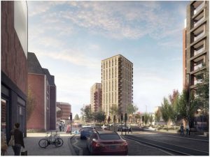
Plans for Bull Hill Leatherhead (image Leret Group)
.
.
.
.
.
.
Epsom & Ewell’s Council responds to Local Plan concerns
9 March 2026
Epsom and Ewell Borough Council has responded to questions raised about the handling of its Local Plan examination, following criticism from a local resident that key issues were not discussed at the January meeting of the Licensing and Planning Policy Committee (LPPC).
The concerns, raised by Alex Duval and subsequently put to the council by Epsom & Ewell Times, centred on the absence of any Local Plan item on the LPPC agenda, whether revised evidence requested by the Planning Inspector had been submitted on time, and how the plan is being managed during the transition to a new unitary authority.
No committee decision required, says council
Responding to the first point, a council spokesperson said that although the Planning Inspector had requested additional work on two areas of the Local Plan evidence base following the public hearings in autumn 2025, no LPPC agenda item was required on 22 January because no formal decision was needed.
“The Local Plan Inspector requested that the planning authority undertake two pieces of work, as set out in her post-hearing letter dated 22 October 2025,” the spokesperson said.
“There was no item on the agenda for the Licensing and Planning Policy Committee on 22 January 2026 as there was no decision to be made in relation to the submission of this evidence base.”
Critics had argued that, given the significance of the work and the proximity to the council’s own stated submission deadline, the committee should at least have been asked to note or review the position.
Evidence submitted by deadline
On the question of whether revised Green Belt and Land Availability Assessment material had been submitted by the deadline of 22 January 2026, the council confirmed that it had.
“Yes, the work was submitted by the agreed deadline,” the spokesperson said.
“The Planning Inspector will review the information in due course and advise how the examination will proceed.”
At the time the concern was raised, the updated material was not visible on the examination website, prompting uncertainty among observers about whether the deadline had been met.
Examination remains Inspector-led
Addressing wider concerns about how the Local Plan will be managed as Epsom and Ewell moves towards abolition under local government reorganisation, the council said the examination process remains unaffected.
“Following the submission of the Local Plan in March 2025, approved by Full Council on 10 December 2024, the Local Plan entered its Examination stage, which is led by the appointed Planning Inspector,” the spokesperson said.
“This will continue to be the case until the Examination stage concludes.”
The council’s response does not address whether any further member oversight or discussion of the Local Plan will take place before the examination ends, but confirms that responsibility for the process now rests with the Inspector rather than the council’s policy committees.
…and many more – search “local plan” in our search box.
Redhill developers make a towering mistake
9 March 2026
Two major landmark towers that would have dominated a Surrey town have been dismissed with campaigners claiming a major victory in their long-running battle. Developers Solum Regeneration had been hoping to build high-rises of 14 and 15 stories next to Redhill station, but were refused planning permission by Reigate and Banstead Borough Council in 2024. Undeterred, they dug in and challenged the decision through the courts forcing a long drawn-out process. Residents, however, galvanised to challenge the process.
Now, they are celebrating after the planning inspectorate threw out the bid to create Redhill’s tallest buildings saying it would forever harm the town’s character, blot out existing views of wooded hills outside Redhill, and create pedestrian safety risks. Redhill Residents Action Group (RRAG), formed to represent hundreds of residents and rail users.
The appeal, brought by Solum Development, a partnership between Network Rail and Keir, was opposed on planning grounds relating to design quality, impact on heritage and town character and the effect on access to a vital transport hub.
Jan Sharman, Campaign lead for RRAG said: “We have always believed this was the wrong development for such an important site. Redhill station should be embracing the future, with integrated rail, bus and active travel. “Developers need to think with vision and create places that genuinely work for communities.”
Solum had insisted the development was needed for the town and would deliver 255 much needed housing to the area – particularly as the council is missing its targets. The scheme would have also revamped the railway station, and increased footfall to town centre.
The taxi rank would have been relocated to the back of the station, with most drivers and cyclists directed to the steep Redstone Hill entrance. Disability campaigners said this would shut those mobility issues out. The inspector however decided the sheer size of the scheme was just too much.
Jan added: “We fully recognise the need for more homes, particularly for younger people. But homes must be genuinely affordable, well designed and properly integrated into their surroundings. Building housing that people cannot afford, in the wrong place, helps no one.”
The inquiry was held over September 2 to 5 and continued between November 24 to 28 last year. Planning inspector Joanna Gilbert issued her decision on January 19, 2026. She said: “The proposal would provide the benefit of 255 housing units that carries substantial weight. There would be other benefits to which I have afforded significant, moderate and limited weight. However, I have afforded very substantial weight to the adverse effects on the character and appearance of the area.”
“There are moderate, limited and very limited levels of less than substantial harms to designated heritage assets and a moderate indirect adverse effect on a non-designated heritage asset. There would also be significant weight to the harm in respect of highway and pedestrian safety, including parking. Additionally, there would be moderate weight to the harm to living conditions for some occupiers of Quadrant House.”
She added: “For the reasons set out above, the appeal is dismissed.”
Redhill Train Station development 15-storey tower block distance CGI (Credit Solum planning documents)
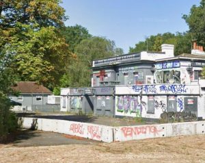
Council’s refusal leaves Esher’s Marquis of Granby derelict
9 March 2026
The owners of the Marquis of Granby in Esher have hit back at Elmbridge Borough Council after it refused to recognise the venue as a restaurant. They said the decision they say is “wrong” and “based on a misunderstanding”.
Greene King, which owns the site on Portsmouth Road, has now submitted a fresh planning application asking for a Certificate of Lawful Existing Use. They want official confirmation that the Marquis of Granby should be classed as a restaurant, not a pub.
They argue the council made a “fundamentally flawed” decision last year when it rejected their original application in November 2023.
According to Greene King, the venue has operated primarily as a restaurant since 1994, with alcohol sales playing a secondary role. In simple terms: most people went there to eat, not just to drink.
Elmbridge council, however, ruled that the premises looked more like a “drinking establishment with expanded food”, a specific planning category used for pubs that also serve meals. The classification puts it outside the normal restaurant category and limits what the building can be used for in future.
Although 77.8 per cent of its sales come from food, officers said in their 2023 report, this is typical for modern pubs, which commonly serve meals, and pointed to industry data showing similar patterns nationwide. They also highlighted pub-style features including a large bar area, self-seating, multiple beer taps, a cellar stocked with kegs, gambling machines, event nights with DJs, and the venue’s own website branding itself as a “local pub”. The council found these characteristics outweighed the presence of a restaurant area and concluded the premises more closely resembles a pub, not a restaurant, leading them to refuse the certificate.
But Greene King strongly disagrees. They say the council has misunderstood the planning rules and how they apply to the site. Their planning consultants argue:
The Marquis of Granby has never been a drinking-led pub, so it cannot suddenly be classed as one.
Planning rules do not allow a restaurant to automatically change into a “drinking establishment with expanded food” without permission.
The business was still food-led even after its carvery deck was removed in 2020.
Features like a bar, beer taps and a garden do not automatically make somewhere a pub and many restaurants have these too.
They also say the council relied too heavily on a trade magazine article about pub food and drink sales, which they describe as “meaningless” evidence.
Greene King points out that it successfully secured the same certificate for six similar venues elsewhere, with no objections from councils. The Marquis of Granby is the only one that has been refused.
Since closing, the building has become run down, with heavy graffiti, vandalism and anti-social behaviour. Greene King says the lack of a certificate is “sterilising” the site and stopping it from being reused and that it is now a potential fire risk.
A spokesperson said the evidence clearly shows the venue was laid out for dining, with large kitchen facilities, menus focused on meals, tables set with cutlery and condiments and most of the space is dedicated to seated customers. They argued this proves food was the main attraction.
Greene King is now asking the council to reconsider and approve the certificate without delay. If granted, it would officially confirm the Marquis of Granby as a restaurant, making it easier to bring the site back into use.
The council has not yet commented on the new application.
Marquis of Granby pub on Portsmouth Road, Esher. (Credit: Google Street View)
.
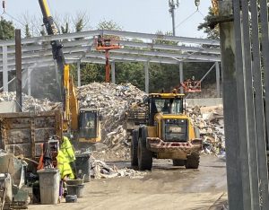
Epsom waste site plans refused after years of noise and disruption complaints
9 March 2026
Plans to retrospectively approve changes at a controversial waste and recycling site near Epsom have been refused, following years of complaints from residents about noise, dust and early-morning lorry movements.
Surrey County Council’s planning committee voted to reject the application for land at the Chalk Pit on College Road, where skip hire firm Skip It Epsom Ltd operates, at a meeting on December 17.
Residents speaking at the meeting and objecting to the scheme online slammed the plans. They described how the site had been “destroying their lives” and making it a misery with constant noise, intruding on their home life and impacting nearby schools. Locals complained that site has not been built according to its planning permission.
The application was not for a brand-new site, but to regularise changes that had already been made to buildings and operations at the former waste transfer station, which was granted permission in 2023 to become a materials recycling facility.
However, councillors were told the development had not been built as approved and crucially, a required drainage system was never installed.
The operator wanted permission to change several conditions attached to the original approval, including:
Buildings being built on a different footprint and with altered materials
A new entrance and staircase
Moving noisy waste-sorting machinery into a different building
Changes to HGV parking and electric vehicle charging points
Officers described most of these changes as relatively minor and, on their own, acceptable even though the site sits in the Green Belt.
So why was it rejected? The refusal came down to one major issue: drainage. Councillors heard that the surface water drainage scheme approved in 2023 had never been installed, and that new assessments now showed a much larger soakaway was needed.
But part of the required drainage system would sit outside the application site, meaning it could not legally be approved or enforced through this planning application.
As a result, officers said an essential planning condition could no longer be met or reimposed, leaving the council with no option but to recommend refusal.
Local residents spoke passionately against the application at the meeting, describing years of disruption since operations ramped up in 2020.
Bernie Muir, local councillor for Epsom, told the committee that the site had been “destroying lives for five years”. She said: “People can’t use their gardens, open windows or work from home […] There are serious mental health impacts from the constant noise.”
More than 170 objections were submitted overall. Residents complained of:
Banging, clanging and crashing from skips being dropped
Heavy lorries arriving as early as 5.30am
Dust, light pollution and breaches of operating hours
Noise carrying across the landscape due to the bowl-shaped chalk pit
Fiona, who lives around 350 metres from the site, said she had no problems for years after moving to the area until operations changed. “On some days the noise I experience in my garden is banging, clanging and repetitive crashing,” she said.
She also raised concerns about drainage, saying the site sits near a protected groundwater zone and the chalk geology is highly porous. “This is an unfixable flaw,” said John Beckett, an Epsom and Ewell borough council member.
Residents’ groups also argued that moving noisy machinery and changing the building entrance had directed sound towards homes that were never properly assessed in earlier reports.
Speaking for the applicant, a representative said she was aware of concerns but claimed the developer had not been invited to some of the multi-agency meetings.
Cllr Tim Hall said he was “surprised” by the claim, given the number of meetings held with residents, agencies and council officers over five years.
The applicant’s agent defended the criticism by describing the chalk pit as a “very busy site” and it is difficult to keep all the workers across the procedures to keep the doors closed and noise down. She also said the early starts referred to residents were “alleged breaches on the site” and the noise could be coming from elsewhere nearby.
Some councillors acknowledged residents’ frustrations, while others pointed out the site has long been industrial. Cllr Ernest Mallett MBE said: “At the end of the day, people bought houses next to an industrial site.” But others felt the problems went beyond normal industrial impact.
The refusal does not shut the site down but it does mean the unauthorised changes cannot be approved. To move forward, the operator would need to submit a new full planning application, including a drainage solution that can be properly assessed and enforced.
Surrey countryside campaigners warn new planning rules risk more speculative development
9 March 2026
Local countryside campaigners have voiced strong concerns over the Government’s newly announced changes to the National Planning Policy Framework (NPPF), warning that the reforms could increase speculative development across Surrey without delivering the affordable housing and infrastructure communities need.
The changes, announced by the Housing Minister this week, form part of the Government’s wider pledge to accelerate housebuilding and address England’s housing shortage. Ministers say the revised framework is intended to simplify the planning system, reduce delays, and ensure local authorities play a more active role in meeting housing need.
Among the key changes outlined by the Government are a renewed emphasis on meeting housing targets, revisions to how land supply is assessed, and proposals to allow some areas of the Green Belt to be reclassified as so-called “grey belt” land where development is judged to have limited environmental or landscape value. Ministers have also argued that the reforms will reduce repeated legal challenges and appeals that, they say, slow down development.
Responding to the announcement, CPRE Surrey said it was “deeply concerned” that the changes would fail to meet their stated aims while placing greater pressure on countryside land.
Andy Smith of CPRE Surrey said the proposals were “unlikely to meet the Government’s aim of speeding up housebuilding but will certainly blight more of our countryside with the shadow of unwanted development”.
“Yes, we need more affordable housing but these proposals won’t achieve that,” he said. “What we will see is a further increase in speculative development which boosts the profits of developers but will not produce the housing or public services that we really need.”
CPRE Surrey has questioned why the Government is pursuing development on Green Belt land when national figures indicate there is capacity for at least 1.4 million new homes on brownfield sites across England. Campaigners argue that the absence of a legally enforceable “Brownfield First” policy means developers will continue to prioritise greenfield sites, where land values are higher and projects are more commercially attractive.
“Why, when across England there is space for at least 1.4 million new homes on brownfield sites, does the Government still want to reclassify much of the Green Belt as ‘grey belt’ and build on it?” Mr Smith asked. “Why do Ministers want us to lose farmland and open spaces to the developers?”
The Government has also said the changes are intended to prevent repeated attempts to overturn planning decisions. In Parliament, the Housing Minister said the reforms would help end a system that allows parties to “come back again and again if they don’t get the outcome they want”.
CPRE Surrey disputes that characterisation, arguing that it is developers, not local communities, who benefit from repeated appeals. Mr Smith said that if a planning application is approved by a Surrey council, local residents generally have no right of appeal, whereas developers can submit multiple revised applications or appeals following refusals.
“Developers can indeed ‘come back again and again’ with appeals and revised, often barely changed, planning applications, aiming to wear down the objectors,” he said. “The proportion of legal challenges brought by local communities is tiny compared to the number of developments that are pushed through.”
While ministers insist the revised NPPF will streamline decision-making and unlock new housing supply, CPRE Surrey said it could not see how the changes would genuinely speed up development or improve outcomes for communities.
“All these changes will do is play into the hands of speculative developers,” Mr Smith said.
The revised National Planning Policy Framework is expected to guide planning decisions across England once formally adopted, with local authorities required to update their planning policies in line with the new national framework.
Blockbuster cinema and 480 homes plan for Leatherhead town centre
9 March 2026
Hundreds of new homes in blocks of up to 12 storeys high, as well as a three-screen cinema, could be coming to Leatherhead town centre if newly submitted plans are approved. The Leret Partnership, a joint venture between Mole Valley District Council and Kier Property, has submitted its formal application to regenerate the Swan Centre and Bull Hill in Leatherhead. They want to build up to 480 new homes with 81 of those, spread between two blocks, classed as affordable. The site, already set aside for development as part of the council’s local plan, would also get a cinema.
The plan has been submitted as a single build but is split across two distinct sites: Bull Hill and the Swan Centre. Detailed plans show Bull Hill will be converted into six blocks of 276 homes, 133 of which will be one-bed flats, with a further 133 two-bed apartments and 10 three-bed homes. The 81 affordable homes will be housed in blocks E and F. The private blocks will be six storeys high while block E will stand five storeys tall and block F rising to nine storeys. There are also further outline plans to go up to 12 storeys at the site to provide an additional 203 homes, office space and potentially a nursery.
The second part of the application covers The Swan Centre, which has served as Leatherhead’s shopping hub since it was constructed in the 1980s. The plans want to demolish Leret House to open the space and create a new public square with a three-screen 239-seat cinema. “The Applicant has been in discussion with leisure agents and cinema operators and the building has been designed to accommodate other leisure uses (competitive socialising) should the occupier change in the future”, planning documents read.
There are also plans to build a new multi-storey car park, office space, as well as a potential GP surgery, shops, and cafes and restaurants. The council described the submission of the planning application as a key milestone in its Transform Leatherhead regeneration and that, when built, it will bring more people into the town centre. It also expects to receive about £9m in developer contributions, which can then be used on infrastructure and community improvements elsewhere in the borough. Residents are able to submit their views to the council before its planning committee votes on the proposals.
Cllr Keira Vyvyan-Robinson, cabinet member for property and projects, Mole Valley District Council, said: “The submission is a significant milestone in the delivery of the Transform Leatherhead programme and a real step forward in boosting Leatherhead’s unique position as the gateway to the Surrey Hills. The proposals will breathe new life into Leatherhead’s town centre, rejuvenate the Swan Centre and deliver much-needed homes for the district, providing jobs and securing sustainable investment for the local community.”
A leafy Surrey suburb is about to make its mark for the local community. Stoneleigh and Auriol are poised to be able to say ‘yes’ or ‘no’ to planning developments that do not match their design plan for the neighbourhood with legal backing.
Members of Epsom & Ewell Borough Council’s (EEBC) licensing and planning policy committee gave the new local scheme the go ahead to move to the next stage on November 25. The Stoneleigh and Auriol Neighbourhood Plan (SANP) is the first of its kind in Surrey’s smallest borough.
“This plans’ compilation has taken an immense amount of effort by all those involved and it’s been an enormous undertaking,” said Cllr Tony Froud (RA Stoneleigh), part of the SANP working group. “The remarkable thing about this is they [the residents group] have done it all on their own with just a keen interest in preserving the character of the neighbourhood. It’s an immense body of work by residents, lay people and non-professionals. Due to the costs involved, no outside help could be sought or brought in.”
The SANP, along with some tweaks, is set to go to a public referendum in February 2026. If residents vote ‘yes’, this plan will become law for the area. This will shape what can be built, how it looks and protect things like shops, green spaces, housing character, and more.
If adopted, future planning applications in Stoneleigh and Auriol will be judged against the neighbourhood plan’s policies as well as broader strategic policies.
For locals, that could mean tighter control over what gets built. This aims to preserve the area’s distinctive character, leafy streets and sense of community, while still allowing carefully managed change. The SANP must strike a balance between protecting what residents love and accommodating new housing and development where appropriate.
The journey has not been quick. The neighbourhood forum behind the plan took on the task over five years ago in gathering evidence, consulting residents, drafting policies, and refining proposals.
Cllr Alex Coley (Independent Ruxley) said: “This has been a great example of what residents can do when they want to put together really clear guidance around planning.” He told the committee that not every group of residents can put in the amount of work, time and effort into making a neighbourhood plan rather than campaigning and protesting about developments and planning decisions.
After the Plan was submitted to EEBC in May 2025, a six-week public consultation took place between June 20 and August 1. Eight organisations and individuals, including expert bodies, submitted comments. An independent examiner was then appointed and delivered their report on 23 October 23, recommending the plan proceed to referendum subject to a number of changes.
Council planners and the neighbourhood forum have now accepted all the examiner’s recommendations. The revised plan contains 11 clear policies, setting out rules for building, design, green spaces, flood risk, transport and more.