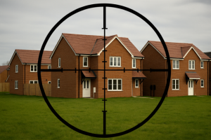

Surrey villagers say they fear their semi-rural community will be “overwhelmed” by development.
Ripley is frequently named one of the prettiest and best places to live in Surrey. But locals are worried it could soon lose the charming character that drew them there as plans for up to 540 homes on farmland edge closer to submission.
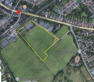
The proposed development of Grove Heath North, between Ripley and Send, would see hundreds of two- and three-storey houses built on farmland off Portsmouth Road. While the scheme is still at the environmental scoping stage, locals say the scale alone is enough to change the face of the historic village for good.
‘Completely out of character’
Brian Crosby, chairman of the Grove Heath North Residents’ Association, moved to Ripley 33 years ago from Twickenham for what he calls its “semi-rural character”.
Brian said: “We want to maintain the identity of villages at the edge of the countryside. This [development] just doesn’t sit comfortably behind the existing houses. It would virtually join Ripley to Send Marsh creating more urban sprawl.”
He described the proposal as a major speculative development that is not currently identified as a potential development site in the Local Plan and is a complete shock to our residents who are in disbelief, adding: “The developers do not care what happens to the village afterwards.”
To add insult to injury, the scheme also borrows the very name of Brian’s road, Grove Heath North, which is almost opposite the site. He said he has raised the issue with the developer, arguing it will be confusing for emergency vehicles or delivery drivers in future.
Residents are particularly concerned about three-storey homes, which they say would be “completely out of character” in a village proud of its heritage and historic High Street, once known as the first stop on the coaching route to Portsmouth from the 16th century. The Allium Park Development a mile up the road has 3 storey building being built and these are completely out of character.
While Brian accepts more homes are needed, he argues they should not be built on greenbelt farmland. “This is the easy option,” he said. “The land is used for agriculture. Don’t we need more farmers and people producing food for our country?”
Plans include a new village green, a nature trail and suggests a new local shop. However, the application does not clarify if the developers would build it and the new store would be located next to an existing farm shop.
But Brian said it felt like it was part of a tick-box exercise. “Ripley has one of the largest village greens in the country,” he said. “Giving us effectively what we have already got isn’t adding anything. Sally added the proposed site already had public right of way footpaths running across it.
The developer response
A Green Kite Homes spokesperson said: “This site presents an opportunity to deliver a landscape-led development of new homes and community uses in a highly sustainable location. Our proposals would address identified local housing needs, delivering homes in a range of sizes and tenures.
“We have also listened carefully to feedback received during the public consultation and, as a result, have decided to change the name previously used for the site. We will be engaging further with the local parish councils on this.”
Fears over traffic, schools and sewage
Brian and fellow resident Sally pointed to other large schemes in the wider area, including Wisley Airfield (around 2,000 homes), Gosden Hill (1800 homes), Send Marsh (140 homes) and Allium Park (around 620). They argued there is no “joined-up thinking” about the cumulative impact on roads, schools, doctors and drainage.
Sewage capacity has sparked particular anger. Brian claimed the local works are already struggling and have discharged into the River Wey during heavy rainfall in the last few weeks. They pointed to comments from Thames Water indicating major upgrades are not due to be completed until 2030 and Ripley Sewage plant would not be able to meet Government targets for storm overflows until 2045-2050, and questions whether new homes should be occupied before then.
They questioned the pressure on already stretched services. Brian and Sally warned there is only one GP surgery in neighbouring Send which serves both Ripley and Send and one private dentist in Ripley. “The surgery has already had to increase patient numbers and cannot physically increase further,” they said. “Where are all these people going to go?”
There are also claims the local primary school is oversubscribed and there are no local secondary schools nearby, and fears that hundreds of additional commuters would pile a “burden of traffic”. They said roads are already busy, with effectively one main route running through the village, which is often used as a cut-through despite the A3 bypass since there aren’t on and off connections to the A3 at each end of the village.”
A Green Kite Homes spokesperson said: “As part of the planning process, we will continue to work closely with the council and statutory consultees to ensure that local infrastructure can appropriately support development of this scale. This will also include financial contributions towards infrastructure upgrades as part of any future planning consent for the site.”
The current submission is only about setting the scope of environmental studies, not approving the homes themselves. Guildford Borough Council’s decision on the EIA will determine what issues must be examined in detail before any full planning application is considered.
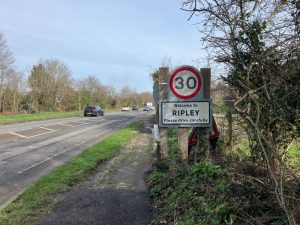
Ripley village sign. (Credit: Emily Dalton/LDRS)