

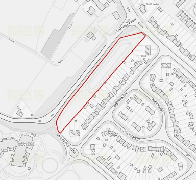
Land at Chantilly Way


This is the eighth of nine reports on the nine BIG PLANS for Epsom and Ewell proposed in the DRAFT LOCAL PLAN that is out for public consultation till 17th March. We do not intend to state any support or opposition but may ask some questions.
This 0.7 hectare grazing land is earmarked for residential development. The reasons given include:The site will contribute towards meeting the need for housing in the borough and lies adjacent to the Strategic Allocation at Horton Farm (Policy SA6).
The site has well defined boundaries and lies on a transport corridor adjacent to existing residential area, creating a suitable context for residential development. The site is also in relatively close proximity to local services and facilities and to public transport connections.
Planning officers note that the development should not adversely affect any protected trees near the boundary of the site. Any development proposal will need to incorporate mitigation relating to surface water flooding for those parts of the site that are susceptible.
The council is working with key infrastructure providers, including Surrey County Council as the Highway Authority and Education Authority, Clinical Commissioning Groups and Utility providers to determine exactly what infrastructure is required to support the proposed development.
When will the site be developed?
It expected that a planning application will be submitted in the early part of the plan period with development likely to start by 2028.
Related Reports:
Epsom & Ewell Borough Council Draft Local Plan. Details how to submit your views.
The BIG plans for Epsom and Ewell – reports on Hook Road Car Park and SGN site plan.
The Epsom and Ewell Town Hall plan
A new Town Hall for Epsom and Ewell?
Local Plan battle heating up? and other related reports.