Epsom and Ewell Times

12th February 2026 weekly

ISSN, LDRS and IMPRESS logos

Possible pause to Plan pondered ……

Planning documents

Epsom and Ewell’s Local Plan is at risk of even further delay after councillors from the ruling Residents’ Association (RA) proposed pausing the process in the face of fierce opposition to proposed Green Belt development.

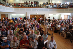
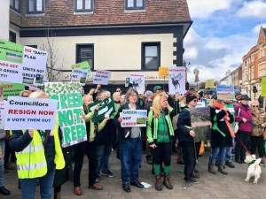
Seven RA councillors are proposing that development of the Local Plan is paused and have triggered an extraordinary council meeting, which is due to take place on 22 March. The meeting was arranged a few days after a protest against Green Belt development in Epsom town centre, which organisers have said involved over 200 demonstrators.

The Plan is currently subject to public consultation, which is set to run until 19 March.

Local elections will take place on 4 May.

Councillor Eber Kington (Residents’ Association, Ewell Court Ward), who will propose the motion, said: “My view is that a pause will enable the Borough Council to assess the responses from residents to the public consultation and review any new information on brownfield sites.”

However, it is not clear what impact the “pause” would have. Assessing responses to a consultation is part of the normal process for developing a Local Plan and the motion expressly states that this should continue.

Cllr Kington added that a pause would also allow the council to re-examine brownfield sites previously designated as non-viable.

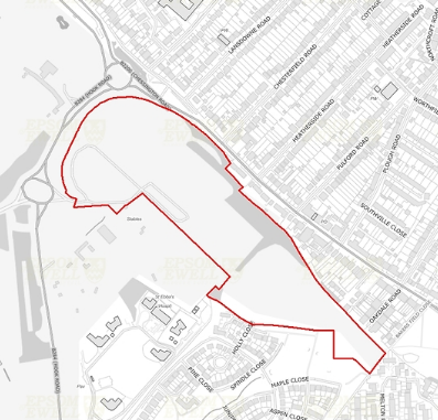
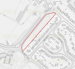
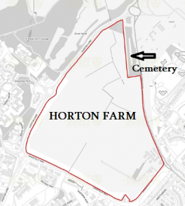
The council did not include the Longmead Industrial Estate or the Kiln Lane area brownfield sites that Chris Grayling (MP) has suggested could be used to meet housing need, in its list of sites for potential development.

You can find out more about the opposing positions and viewpoints, ask your own questions at a Public Meeting on the Draft Local Plan to be chaired by Epsom and Ewell Times on Monday 13th March at7pm at Wallace Fields Junior School, Dorling Drive, Ewell, Epsom. Registration and advance questions optional Click HERE for details.

Councillor Kate Chinn (Leader of the Labour Group, Court Ward) said: “It is unbelievable that this RA council has spent years formulating a Local Plan; bringing in consultants to give advice and briefings; tasking officers to spend hours to formulate the plan; spending thousands of pounds and now there are several of their own members deciding it isn’t what they wanted. It would be expected they would have agreed more of a consensus before reaching this late stage.”

Councillor Julie Morris (Leader of the Liberal Democrats Group, College Ward) accused the RA of overturning “its own decisions very quickly but particularly when there’s an election looming”. She also said that last December, she had asked Cllr Steven McCormick (Residents Association, Woodcote Ward), chair of the Licensing and Planning Policy Committee, to put a “short delay” to the public consultation on a meeting agenda, but the suggestion was not taken up. “They plodded on”, she said, “and tried to keep the whole thing secret”.

In January, the council voted unanimously to launch the public consultation on the Plan. Cllr Morris said: “The reason that I voted for public consultation was that it [the Local Plan] needed to be out there. The RA has gone to such lengths to keep everything quiet.”

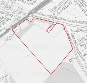
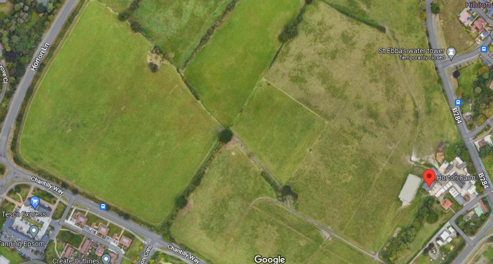
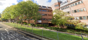
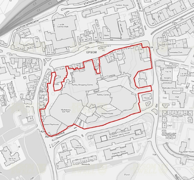
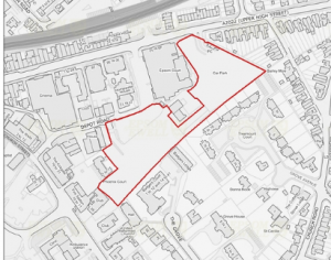
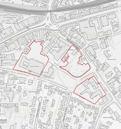
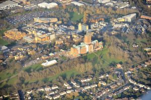
The Draft Local Plan sets out nine sites for potential development in the borough; five are on Green
Belt land. Green Belt land includes areas of countryside that are protected from development in
order to prevent urban sprawl and encourage development within existing built-up areas.

Cllr Kington also said: “Crucially we need to understand the Government’s new legislative proposals,
which are due to be published in May, so that we can factor the new Government’s new approach
into our own plans.”

The proposals set to be published in May are undergoing consultation, including on a revision that
states that “Green Belt boundaries are not required to be reviewed and altered if this would be the
only means of meeting the objectively assessed need for housing over the plan period”.

After Mole Valley District Council wrote to the planning inspectorate asking to remove all Green Belt
sites from its own Local Plan, the inspector agreed to delay hearings until May.

Cllr Kington added: “Finally, we have to continue to campaign against the Government’s continuing
requirement for councils to use 2014 data to develop a 2023 Local Plan. If 2018 data were used, the
number of required homes could be met by the use of brown field sites alone.”

Currently, the Local Plan is due to be adopted in Spring 2025. This would see it miss the government
target of all local authorities having an up-to-date Plan by the end of 2023 – and make it the last
local council in Surrey to adopt a new Plan.

Related Reports

Public meeting on Local Plan

Mole Valley Local Plan paused: official

Can Epsom and Ewell get more dense?

Residents aroused by “sleeping” residents?


Public meeting on Local Plan

A packed Council meeting

On Monday 13th March at 7pm at Wallace Fields Junior School Dorling Drive, Ewell, Epsom KT17 3BH, Epsom and Ewell Times will chair a public meeting on the Draft Local Plan. The meeting will feature a panel of experts. Tim Murphy CPRE, Margaret Hollings Epsom Civic Society and Chair Licensing Planning and Policy Committee Cllr Steven McCormick (Council officers invited). Questions and view points from the public attending will be allowed. We will confirm if the meeting can be followed online in the next few days.

Registration to attend is not required but it would be helpful to us if you did inform us of your intention to attend. This will help some planning. Also it would help the chair of the meeting if you submitted questions in advance.

The Epsom and Ewell Borough Council is holding an extraordinary meeting on 22nd March at 7.30pm at The Town Hall, The Parade, Epsom to discuss a motion about the Draft Local Plan. Only 11 councillors approved the Draft Local Plan going forward at a meeting of the Licensing Planning and Policy Committee of 30th January. The Full Council meeting of the 22nd March will be the first public opportunity for all Councillors to speak on the Local Plan.

You can tell us if you are attending the Epsom and Ewell Times Local Plan Public Meeting and suggest a question by filling in:

Local Plan meeting attendance and question form.

Related reports:

Epsom and Ewell Local Plan meeting times

Mole Valley Local Plan paused: official

Epsom & Ewell Borough Council Draft Local Plan.

Green-belters seeing red on Local Plan?

Hook Road Arena plans and links to many other related reports.


Mole Valley Local Plan paused: official

Mole Valley

Inspectors have agreed to pause the examination of Mole Valley’s 6,000 home blueprint amid attempts to remove all green belt sites for development.

Mole Valley District Council had written to the Planning Inspectorate asking to remove all green belt sites from its draft local plan in anticipation of government changes to the planning system. But these hopes have been dashed by the inspector on the grounds it could not prejudge any prospective changes. Despite the setback, the inspector said they would be happy to delay hearings until May – when any new rule changes become clearer- and that is where things stand.

Local plans are the basis for planning decisions in an area. They outline the type, location and density of development that is likely to be permitted. Without one, developers have much freer range to chance their arms.
The council also does not have a five year housing land supply, which again tips the favour towards developers and increases the urgency with which Mole Valley District Council needs to get its local plan signed off.

Mole Valley District Council’s leader member for planning, Councillor Margaret Cooksey, said that, while disappointed the local plan has been delayed yet again it is a better outcome than having to start the process from scratch.  She said: “I am disappointed we are having to pause and delay.  The longer we are without an adopted plan the more at risk our green sites are. If we carry on we have to work on current National Planning Policy Framework rules and greenfield sites we have in the plan. That is what we are trying to prevent. But if we just abandon the current plan we would have to start from scratch and that would take a lot longer.  We don’t want to lose the good parts of the draft plan.”

She said they have already received an application to build on one of the green belt sites they are trying to remove from the local plan.

The planning inspector  agreed to delay examination of the local plan until May 25 at which time there should be greater clarity around future national planning policy and will also accommodate the implications of the council’s all out local elections in May.

Related reports:

Lessons for Epsom in Mole Valley’s “shouty” Local Plan struggle?

How Green is My Mole Valley?

Can Epsom and Ewell get more dense?


Hook Road Arena plans

Hook Road arena

This is the last of nine reports on the BIG PLANS for Epsom and Ewell proposed in the DRAFT LOCAL PLAN that is out for public consultation till 17th March. We do not intend to state any support or opposition but may ask some questions.

Hook Road Arena is owned by the Council and has for many years been the home of car boot sales, funfairs and annual firework nights. The plan is for residential and sports and recreation development, comprising:

  • A new sports hub for the borough to include playing pitches (grass and artificial) a new pavilion and changing facilities on 9.5ha of the site that will be retained within the Green Belt.
  • At least 150 net zero carbon homes on the eastern part of the site that will be inset from the Green Belt

The reasons given include the site has the potential to deliver recreational sports facilities and playing pitches. The allocation of this site will mitigate any losses of playing pitches (rugby) resulting from the allocation of the adjoining Ewell East Station (see our report HERE) . It may also help to meet additional playing pitch needs for ‘secure provision’ (i.e. community use protected through a legal agreement) both now and in the future.

The site will contribute towards meeting the need for housing in the borough.

When will the site be developed? 

It expected that a planning application will be submitted early in the plan period, with development likely to start in 2027. 

Planning officers note that any development proposal will need to incorporate mitigation relating to surface water flooding for those parts of the site that are susceptible. Also, the site could deliver playing pitches and potentially other supporting infrastructure such as changing facilities and a club house.

Related reports:

The BIG plans for Epsom and Ewell – reports on Hook Road Car Park and SGN site plan.

Depot Road plans

West Park

Ashley Avenue

The Epsom and Ewell Town Hall plan

A new Town Hall for Epsom and Ewell?

Epsom & Ewell Borough Council Draft Local Plan. Details how to submit your views.

Local Plan battle heating up? and other related reports.


Land at Chantilly Way

Chantilly Way development area

This is the eighth of nine reports on the nine BIG PLANS for Epsom and Ewell proposed in the DRAFT LOCAL PLAN that is out for public consultation till 17th March. We do not intend to state any support or opposition but may ask some questions.

This 0.7 hectare grazing land is earmarked for residential development. The reasons given include:The site will contribute towards meeting the need for housing in the borough and lies adjacent to the Strategic Allocation at Horton Farm (Policy SA6).

The site has well defined boundaries and lies on a transport corridor adjacent to existing residential area, creating a suitable context for residential development. The site is also in relatively close proximity to local services and facilities and to public transport connections.

Planning officers note that the development should not adversely affect any protected trees near the boundary of the site. Any development proposal will need to incorporate mitigation relating to surface water flooding for those parts of the site that are susceptible.

The council is working with key infrastructure providers, including Surrey County Council as the Highway Authority and Education Authority, Clinical Commissioning Groups and Utility providers to determine exactly what infrastructure is required to support the proposed development.

When will the site be developed?

It expected that a planning application will be submitted in the early part of the plan period with development likely to start by 2028.

Related Reports:

Epsom & Ewell Borough Council Draft Local Plan. Details how to submit your views.

The BIG plans for Epsom and Ewell – reports on Hook Road Car Park and SGN site plan.

The Epsom and Ewell Town Hall plan

Ashley Avenue

West Park

A new Town Hall for Epsom and Ewell?

Local Plan battle heating up? and other related reports.


Residents aroused by “sleeping” residents?

Protest in Epsom against green belt plans

Amid claims of the Residents Association Councillors being “asleep at the wheel” one of the biggest residents’ protests ever held in Epsom took place yesterday. Over 200 demonstrators waved banners, wore green or green belts, and chanted “Green not Greed” in the town centre on Saturday (February 25).

Fury was directed at not only the EEBC planners’ Draft Local Plan containing proposals to build 2,175 homes on Green Belt sites, but also the controlling Residents Association councillors group, which, it is claimed, “were asleep at the wheel” in voting Green Belt inclusion through. Over 40% of the total 5,400 Local Plan homes are destined for the Green Belt, the majority of which will be market-priced and unaffordable to those starting out on the property ladder, protestors argue.

Of nine “preferred options” for housing sites earmarked by the Council in the Local Plan, five are on Green Belt sites, which include Horton Farm (1,500 homes proposed) and Ewell East playing fields (350 homes, up to six storeys high).

Despite a “brownfield first” brief, planning officers have not proactively engaged with developers on central urban rejuvenation possibilities, near facilities, preferring instead to accept opportunistic bids from selected Green Belt landowners and developers, protestors claim.

In a display of some cross party support, the protestors were joined by representatives from political parties standing in forthcoming local elections in Epsom & Ewell, including two RA councillors who had voted against their colleagues on Green Belt inclusion. Cllr Eber Kington (RA Ewell Court Ward) and Cllr Christine Howells (RA Nonsuch Ward). They were joined by Cllr Bernie Muir (Conservative – Stamford) and Mark Todd Chair of the Epsom and Ewell Labour Party.

Demonstration organiser, Kathy Mingo, from the Epsom & Ewell Green Belt Group, said “It was heartening to see everyone uniting beyond party political lines against these unjustified Green Belt destruction plans, given new emerging Government guidelines that puts the focus squarely on brownfield development to meet only advisory, not mandatory, housing targets”

Alex Duval, vice-chairman of Clarendon Park Residents Association, which adjoins the Horton Farm Green Belt site said “ The data does not add up. The Council’s own reports show that the site contains a critical drainage area with high flood risk; their transport analysis recommends not taking the site forward; and reliance on outdated ONS 2014 population figures – rather than the lower  2018 and official 2021 Census figures – means Epsom’s housing needs are significantly overstated. The real housing need can be accommodated on brownfield alone, without any Green Belt destruction.Their own evidence is clear – the Council should save our Green Belt”

Tim Murphy, a vice president of CPRE Surrey and chair of Epsom’s CPRE group, said “CPRE’s experience is that, once sites are listed in a Council’s Local Plan as a “preferred option” for development, then, in 99% of cases, they eventually get developed. So EEBC has already put a number of Green Belt sites at real, permanent risk by identifying them for housing in its Draft Local Plan, which may not be justified as current Government policy on Green Belt evolves”

“Many RA councillors’ seats may now be at risk in May if they do not join the minority of their colleagues in clearly stating their policy objection to unjustified Green Belt destruction” said Jenny Coleman, chair, Ewell Downs Residents Association. “It is clear, not least from a residents petition signed by over 7,000, but also from this impactful, united residents protest, that many think the RA councillors have been rather asleep at the wheel. They must listen to the voice of the people”.

Epsom & Ewell Borough Council Draft Local Plan. Details how to submit your views.

A petition is available at epsomgreenbelt.org

Related reports:

The BIG plans for Epsom and Ewell – reports on Hook Road Car Park and SGN site plan.

MP’s housing solution for Epsom and Ewell

The Epsom and Ewell Town Hall plan

A new Town Hall for Epsom and Ewell?

Land adjoining Ewell East Station

Land at West Park Hospital 

The really BIG one: Horton Farm

Ashley Avenue

West Park

Local Plan battle heating up? and other related reports.

Local Planning Matters – Tim Murphy’s opinion piece for Epsom and Ewell Times


Land adjoining Ewell East Station

Ewell east plans

This is the seventh of nine reports on the BIG PLANS for Epsom and Ewell proposed in the DRAFT LOCAL PLAN that is out for public consultation till 17th March. We do not intend to state any support or opposition but may ask some questions.

This 8.3 hectare sports pitches and open space is earmarked for residential development with the following justifications:

  • At least 350 net zero carbon dwellings
  • Building heights up to 6 storeys
  • New local retail provision at ground floor
  • The re-provision of the playing pitches at Hook Road Arena

The site will contribute towards meeting the need for housing in the borough and ancillary community infrastructure.

The site has well defined boundaries and lies adjacent to existing residential areas and adjoining Ewell East railway station, creating a suitable context for residential development and lowering the risk of adverse landscape impacts. The site is also in relatively close proximity to local services and facilities and to bus and rail transport connections. Vehicular access can be achieved without detriment to the character of the local area.

When will the site be developed?

It expected that a planning application will be submitted in the middle of the plan period with development likely to start by 2031 once new sports pitches have been provided.  

Planning officers note:

Development proposals must identify ways of improving pedestrian access to Ewell East Station and maximise the linkages between the site and surrounding area, and provide opportunities for walking and cycling.

The design of development would need to minimise impacts on Priest Hill Nature Reserve (Site of Nature Conservation Importance (SNCI) located on the Southern Boundary of the site.

Part of the site to the east along Cheam Road is within Flood Zone 3. Any development proposal will need to take this into account.

The development proposal will need to work with the topography of the site to ensure that visual impacts of development are minimised

Infrastructure requirements include:

Provision of new retail unit(s) to provide convenience retail to meet local needs.

The loss of playing pitches will require reprovision at the Hook Road Arena site (Policy SA9). The developer will be expected to re-provide the playing pitches off site prior to development commencing to ensure that the scheme is acceptable in planning terms.

Related reports:

Epsom & Ewell Borough Council Draft Local Plan. Details how to submit your views.

The BIG plans for Epsom and Ewell – reports on Hook Road Car Park and SGN site plan.

The Epsom and Ewell Town Hall plan

A new Town Hall for Epsom and Ewell?

Ashley Avenue

West Park

Local Plan battle heating up? and other related reports.


Land at West Park Hospital 

West Park aerial view

This is the sixth of nine reports on the BIG PLANS for Epsom and Ewell proposed in the DRAFT LOCAL PLAN that is out for public consultation till 19th March. We do not intend to state any support or opposition but may ask some questions.

The plan is for residential development, comprising:

  • approximately 150 dwellings
  • A target of 5% of homes to be provided through the provision of serviced plots of land for self-build and/or custom-build homes
  • Floorspace to support NHS services (if required)

The reasons given include:

The site will contribute towards meeting the need for housing in the borough.

The site comprises of two parcels north and south of existing West Park Hospital residential area. The areas are currently previously developed land within the Green Belt, consisting of buildings that are currently in use as part of the original West Park Hospital operation which are no longer fit for purpose.

The site lies adjacent to existing residential creating a suitable context for residential development and lowering the risk of adverse landscape impacts.

When will the site be developed?

It expected that a planning application will be submitted in the early part of the plan period with development likely to start by 2027.

Site Constraints and mitigation

  • Northern parcel is adjacent West Park Conservation Area and Southern parcel is within the Conservation Area therefore any proposal should ensure it is sensitively designed to reflect the parkland setting
  • Maximise the linkages between the site and surrounding area; and provide opportunities for walking and cycling.
  • Development should not adversely affect the Protected Trees within and on the boundaries of the of the site.
  • Work with the topography of the site to ensure that visual impacts of development are minimised.
  • Development proposal to focus the built form to the north of the site to preserve the undeveloped (open) land to the south.
  • Any development proposal will need to incorporate mitigation relating to surface water flooding for those parts of the site that are susceptible.

The NHS may require the provision of some floorspace for healthcare needs, however there is currently no certainty as to whether there will be a need for such floorspace.

Epsom & Ewell Borough Council Draft Local Plan. Details how to submit your views.

The BIG plans for Epsom and Ewell – reports on Hook Road Car Park and SGN site plan.

The Epsom and Ewell Town Hall plan

Ashley Avenue

A new Town Hall for Epsom and Ewell?

Depot Road plans

Local Plan battle heating up? and other related reports.


The really BIG one: Horton Farm

Horton Farm

This is the fifth of nine reports on the BIG PLANS for Epsom and Ewell proposed in the DRAFT LOCAL PLAN that is out for public consultation till 19th March. We do not intend to state any support or opposition but may ask some questions.

This near 100 acre site is a farm, a riding school and “open space” and the plan is to build 1500 + “zero carbon” dwellings on the site.

  • A target of 5% of homes to be provided through the provision of serviced plots of land for self-build and/or custom-build homes
  • A minimum of 10 serviced gypsy and traveller pitches
  • Public open space
  • Green corridor / habitat enhancements

And the reasons given for the plan include:

The site will contribute towards meeting the need for housing in the borough, including making a significant contribution towards the delivery of affordable housing and in meeting the needs of the boroughs Gypsy and Traveller population to create a new community.

The site has well defined boundaries and lies adjacent to existing residential areas, creating a suitable context for residential development and lowering the risk of adverse landscape impacts. The site is also located close to local services and facilities and to bus and rail transport connections. Vehicular access can be achieved without detriment to the character of the local area.

[Epsom and Ewell Times notes that it is also adjacent to the 5 acre Horton Cemetery where 9000 bodies are buried. See www.hortoncemetery.org for details.]

When will the site be developed?

The site is expected to be developed from 2028/29.

The planners note a number of issues:

  • The majority of the site is bordered by existing residential areas. New access points should maximise the opportunities for improved connectivity and linkages in and around the area, in particular for walking and cycling.
  • Development should not adversely affect any protected trees within and on the boundaries of the site.
  • The design of development would need to minimise impacts on the Site of Nature Conservation Importance (SNCI) located to the north-west of the site.
  • Any development proposal will need to incorporate mitigation relating to surface water flooding for those parts of the site that are susceptible.
  • Development should work with the topography of the site to ensure that visual impacts of development are minimised.
  • Horton Farm House is a listed building in the south-east of the site. Therefore, sympathetic design is required.

 The development of the site will require: New highways access to the West and East and Improved pedestrian and cycle infrastructure.

Epsom and Ewell Times can report Horton Farm is owned by The Church Commissioners and is leased to a farmer who has farmed the area for many years. The Council state that a developer has an option on the land.

Related reports:

The BIG plans for Epsom and Ewell – reports on Hook Road Car Park and SGN site plan.

A new Town Hall for Epsom and Ewell?

Ashley Avenue

West Park

Epsom & Ewell Borough Council Draft Local Plan. Details how to submit your views.

Local Plan battle heating up? and other related reports.


Ashley Centre and Global House plan

Global house Epsom

This is the fourth of eight reports on the BIG PLANS for Epsom and Ewell proposed in the DRAFT LOCAL PLAN that is out for public consultation till 17th March. We do not intend to state any support or opposition but may ask some questions.

The plan for this 3.19 hectare site (nearly 8 acres) that presently consists of a shopping mall, a multi-storey car park and offices to the rear is for a mixed use development, comprising:

  • The retention and refurbishment of the Ashley Centre
  • The redevelopment of Global House to provide at least 70 homes
  • Building heights between 5-8 storeys
  • Retention of the Playhouse
  • Maintaining existing planting and green verge along Ashley Avenue
  • Retention of the Multi Storey Public Car Park

Reasons given for the plans include:

There is the opportunity for the comprehensive refurbishment of the Ashley Centre, the shopping centre in Epsom Town Centre. The redevelopment of Global House to the south of the site alongside the refurbishment of the Ashley Centre offers the potential for an upgraded retail environment, improved facilities, and a better utilised site, with the provision of housing. 

The site provides an opportunity to make more efficient use of land in a highly sustainable location. The Ashely Centre makes a valuable contribution towards the town centres retail offer and the council wishes to encourage the refurbishment of the centre to attract new tenants and maintain its vitality and viability. The redevelopment of Global House to provide additional housing will make a valuable contribution towards meeting housing needs. The successful regeneration of this site will attract new residents and businesses to the town centre.

When will the site be developed?

The council expects that a planning application will be submitted in the early part of the plan period. The development of new housing is expected to start in 2027.

The Draft Local Plan document notes:

  • The site adjoins the Town Centre Conservation Area and several Listed buildings. Therefore, sympathetic design is required.
  • The site is within Area of High Archaeological potential, therefore this need to be investigated.
  • The site includes a well used multistorey car park that serves the town centre and may be required to be re-provided. This will need to be investigated.
  • The site will likely need to continue operating throughout any construction stage(s), development will need to be carefully phased, and retail use, parking, servicing issues carefully coordinated.
  • Potential ground contamination to be investigated and adequately mitigated for residential development
  • Potential to improve pedestrian and cycle connectivity including from the site to the town centre

Related reports:

The BIG plans for Epsom and Ewell – reports on Hook Road Car Park and SGN site plan.

A new Town Hall for Epsom and Ewell?

Epsom & Ewell Borough Council Draft Local Plan. Details how to submit your views.

Local Plan battle heating up? and other related reports.

Depot Road plans

The Epsom and Ewell Town Hall plan


Depot Road plans

Depot Road area Epsom

This is the third of nine reports on the BIG PLANS for Epsom and Ewell proposed in the DRAFT LOCAL PLAN that is out for public consultation till 17th March. We do not intend to state any support or opposition but may ask some questions.

Depot Road and Upper High Street

In a somewhat short description provided the plan is for residential development, comprising:

  • At least 100 new homes
  • The reprovision of public parking by the provision of a decked car park including 1x basement level and 4x above ground levels on Depot Road.
  • New access road
  • Building heights ranging between 2 and 4 storeys

And the reasons given are there is an opportunity to make more efficient use of well-located town centre land by re-providing car parking in a decked structure, releasing land for new homes.

Its successful regeneration will attract new residents and businesses to the town centre.

When will the site be developed?

It is expected that a planning application will be submitted for the comprehensive redevelopment of the main site in the early part of the plan period with development likely to start by 2027.

Possible obstacles include:

  • The site lies adjacent to Church Street and Epsom Town Centre Conservation Areas. It is also in the vicinity of several listed buildings. Therefore, sympathetic design is required.
  • Some of the trees within and very near site are protected by Tree Preservation Orders.
  • The site is within an Area of High Archaeological potential.
  • Potential to improve pedestrian and cycle connectivity including from the site to the town centre.
  • Any development proposal will need to incorporate mitigation relating to surface water flooding for those parts of the site that are susceptible.

Council Officers will be available to speak to you in person at the following places

  • Tuesday 21 February 14:30 – 19:30, Bourne Hall, Azalea room
  • Wednesday 22 February 10:30 – 15:30, Community & Wellbeing Centre, Sefton Road
  • Saturday 25 February 11:00 – 16:00, Ashley Centre, Central Square
  • Tuesday 28 February 10:30 – 15:30, Community & Wellbeing Centre, Sefton Road

Related reports:

The BIG plans for Epsom and Ewell – reports on Hook Road Car Park and SGN site plan.

The Epsom and Ewell Town Hall plan

A new Town Hall for Epsom and Ewell?

Epsom & Ewell Borough Council Draft Local Plan. Details how to submit your views.

Local Plan battle heating up? and other related reports.


The Epsom and Ewell Town Hall plan

Rear Town Hall Epsom

This is the second of nine reports on the BIG PLANS for Epsom and Ewell proposed in the DRAFT LOCAL PLAN that is out for public consultation till 17th March. We do not intend to state any support or opposition but may ask some questions.

Town Hall , Hope Lodge & Epsom Clinic

The Town Hall and Hope Lodge Car Park is owned by Epsom and Ewell Borough Council and is being promoted for development. The Epsom Clinic and parking lot to the rear is owned and being promoted for development by NHS Property Services, while the former Epsom Police Station and Ambulance Station is under private ownership

The plan is for a residential development, comprising:

  • A new residential area focussed around Dulshot Green
  • At least 90 new homes
  • The total redevelopment of Town Hall, Hope Lodge Car Park and Epsom Clinic
  • Building heights ranging between 2 and 4 storeys
  • The reprovision of some public parking on the Town Hall site

The reasons given are that the sites provide the opportunity of making a more efficient use of land in a highly sustainable location that is currently underutilised. Its successful regeneration will attract new residents and businesses to the town centre.

When will the site be developed?

It expected that the redevelopment of the area will involve several planning applications based on a comprehensive scheme for the whole area. Planning applications are likely to be submitted early in the plan period with development likely to start by 2028.

Council Officers will be available to speak to you in person at the following places

  • Tuesday 21 February 14:30 – 19:30, Bourne Hall, Azalea room
  • Wednesday 22 February 10:30 – 15:30, Community & Wellbeing Centre, Sefton Road
  • Saturday 25 February 11:00 – 16:00, Ashley Centre, Central Square
  • Tuesday 28 February 10:30 – 15:30, Community & Wellbeing Centre, Sefton Road

Related reports:

The BIG plans for Epsom and Ewell – reports on Hook Road Car Park and SGN site plan.

A new Town Hall for Epsom and Ewell?

Epsom & Ewell Borough Council Draft Local Plan. Details how to submit your views.

Local Plan battle heating up? and other related reports.


The BIG plans for Epsom and Ewell

Plan of Hook Rd Epsom development site

Starting today and the next EIGHT days The Epsom and Ewell Times will publish details of each of the NINE BIG plans for Epsom and Ewell. These plans are proposed in the DRAFT LOCAL PLAN that is out for public consultation till 17th March. We do not intend to state any support or opposition but may ask some questions.

Hook Road Car Park and SGN Site

This near 12 acres site comprises a public car park, retail units, an education establishment and a utilities site containing redundant gas holders.

The site is to be allocated for a comprehensive residential led mixed use development, comprising:

  • At least 640 new homes
  • Student Accommodation (potential for about 400 student rooms)
  • Mixed use ground floor active frontages accommodating space for office, retail and creative start-ups
  • Performing Arts Centre
  • Café
  • Building heights ranging between 2 and 7 storeys
  • Two-level podium parking (i.e., parking underneath a building) with smart technology solution allowing different users to access spaces at different times of the day/evening
  • Provision of a new public square adjacent to the leisure centre entrance
  • A neighbourhood park in the heart of the development with direct connection to the existing Public Rights of Way network
  • Relocated SGN (the gas company formerly known as Scotia Gas Networks) infrastructure
  • Improved public realm and connectivity within the site and to adjoining areas

The reasons for the plans are to regenerate this brownfield site in a highly sustainable location that is currently unattractive and under-utilised. Its successful regeneration is important for the success and attractiveness of the town centre.

There is the opportunity to redevelop the site into a prominent, high-density, mixed-use development, which would result in an improved, attractive and better utilised environment to the eastern gateway of the town centre. New development would offer the opportunity for a better connected and rejuvenated area that would attract new residents and businesses to Epsom Town Centre.

When will the site be developed?

It is expected that a planning application will be submitted for the comprehensive redevelopment of the main site in the early part of the plan period with development likely to start by 2029.

Council Officers will be available to speak to you in person at the following places

  • Tuesday 21 February 14:30 – 19:30, Bourne Hall, Azalea room
  • Wednesday 22 February 10:30 – 15:30, Community & Wellbeing Centre, Sefton Road
  • Saturday 25 February 11:00 – 16:00, Ashley Centre, Central Square
  • Tuesday 28 February 10:30 – 15:30, Community & Wellbeing Centre, Sefton Road

Related reports:

Epsom & Ewell Borough Council Draft Local Plan. Details how to submit your views.

Local Plan battle heating up? and other related reports.


Can Epsom and Ewell get more dense?

Borough map of surrey

Exclusive to the Epsom and Ewell Times we report on the housing targets of every Surrey borough council. Epsom and Ewell is the smallest borough in Surrey with the highest density of population. Yet aims to have the highest density of new housing, according to the draft Local Plan, out now for consultation.

The table below contains the population stated in a Local Plan, if evident in the document. Otherwise the latest population figure from Wikipedia is used.

Table comparing housing plans of Surrey Boroughs

The Local Plans vary in the period covered and some are in drafting flux. The table provides the average per annum new build over a 15 year period for each Council as far as stated or indicated.

Many plans were submitted or adopted before Michael Gove, Secretary of State for Levelling Up, Housing and Communities, indicated November 2022 that “Housing targets remain, but are a starting point with new flexibilities to reflect local circumstances” and “If we are to deliver the new homes this country needs, new development must have the support of local communities. That requires people to know it will be beautiful, accompanied by the right infrastructure, approved democratically, that it will enhance the environment and create proper neighbourhoods. These principles have always been key to our reforms and we are now going further by strengthening our commitment to build the right homes in the right places and put local people at the heart of decision-making.”

The table above does not reflect many variables that may justify different housing targets. For example areas designated as areas of special scientific interest or areas of outstanding natural beauty. Also, there are many demographic variables: distribution of the ages of populations, family sizes and average incomes.

Furthermore, the mix of different housing types of the new builds envisaged in the plans vary from one Council to another. Big houses, small houses or flats etc.

However, the table does provide a broad overview.

Epsom and Ewell’s Draft Local Plan states: “The housing need for Epsom and Ewell generated by the standard method is 576 dwelling per annum, which equates to 10,368 dwellings over the Local plan period. The Councils Housing and Economic Development Needs Assessment (2022) confirms there is no justification to increase the housing need figure over that generated by the standard method.”

“The council considers that the scale of unmet development / housing needs in the borough that would result from pursuing a brownfield only approach provides the exceptional circumstances and justification to make changes to the Green Belt boundaries in the borough.”

You can meet planning officers of Epsom and Ewell Council at the following times and discuss the draft Local Plan.

Monday 13 February 14:30 – 19:30 Bourne Hall, Azalea Room

Thursday 16 February 12:00 – 17:00, Ashley Centre, Central Square

Tuesday 21 February 14:30 – 19:30, Bourne Hall, Azalea room

Wednesday 22 February 10:30 – 15:30, Community & Wellbeing Centre, Sefton Road

Saturday 25 February 11:00 – 16:00, Ashley Centre, Central Square

Tuesday 28 February 10:30 – 15:30, Community & Wellbeing Centre, Sefton Road

How you can express your views on the Local Plan can be seen HERE.

See today’s editorial

Related reports:

Green-belters belted up and beltless

Local Plan battle heating up?

Green-belters seeing red on Local Plan?

Lessons for Epsom in Mole Valley’s “shouty” Local Plan struggle?

Crucial month for local Local Plans?

Gove gives pause for thought on Local Plans?

Local Plan Battle: early skirmishes on Downs Farm

MP’s housing solution for Epsom and Ewell


Blot on Epsom Downs horizon to grow no more?

Woking from Epsom Downs

Ever wondered where are those tower-blocks on the west horizon from Epsom Downs? Our LDRS journalist reports on Woking Council’s consideration of the height of its buildings:

Plans to limit high-rise development in Woking is akin to slamming the stable door shut after the horse has bolted, Surrey County Council’s ex-head of planning has said. On Thursday February 2, Woking Borough Council’s executive committee agreed to press ahead with its goal to create a masterplan that would “provide a long-term vision” for the town centre’s skyline.

It continues work that began in 2021 that included a six-month consultation which garnered more than 850 responses from about 450 individuals and organisations. According to council documents, though, there remain several legal issues the borough must overcome before it adopts the full masterplan, including the fallout of the Planning Inspectorate decision on the Crown Place from December 3 2022 that granted planning permission three towers of  23, 25 and 28 storeys respectively.

The appeal decision has had a “clear implication” for the Masterplan, the report read, “in that it has changed the nature of the townscape” and that “as a minimum, the design principles for this site, including what prospective heights may be appropriate, will need reconsidering.”

Furthermore, the report states, during the public consultation phase, Woking Borough Council received representations from developers regarding the possibility of legal challenges if it were to be adopted.  There is also the financial risk with officers identifying “significant” cost implications and suggesting the only way to “avoid unnecessary additional expense to the taxpayers purse” is not to proceed to adopt the Town Centre Masterplan in its current draft form.

This has caused the council to seek legal advice on how to proceed. Whether the masterplan can ever have the impact the council desires – fewer high rises in the town centre is debated.

Catriona Riddell is a former head of planning at Surrey County Council and current director at Catriona Riddell & Associates. She said: “Woking is a very tiny, very constrained borough with a lot of debate about how high up the developments go. Anywhere from Surrey you can see Woking. Some love it, some hate it. It’s very much Marmite.
“The Government is trying to help local authorities restrict the number of high rises but with Woking, it is going to be difficult as it already has so many. The local plan is in place in Woking and is up to date – that’s what developers will look at. Any supplementary planning won’t have the same status. Developers are used to playing this game. It’s going to be difficult for the council to change this.”

According to council papers, the masterplan will establish an “overarching vision for the town centre to enable designled, sustainable development, such as building new homes, cultivating a thriving retail and business environment and strengthening Woking’s cultural and leisure offer”. 

The report said that the “ambition and need for a clear and robust plan to guide development in the town centre, to give certainty to developers wishing to invest, and provide officers with an effective tool to assess planning applications and defend decisions on appeal remains”. 

This, Ms Riddell says, may be the best way for the authority to move forward. She added: ‘It will be about how to make the area a good place to live and work and the only way is through a masterplan so they are right to go ahead with it but it will be difficult with developers looking to build highrises. It will be very difficult for the council to argue its out of character. Woking has changed massively over the years, that horse has bolted.”


Will Cathedral repairs threaten Canadian WW1 memorial?

Guildford Cathedral aerial view

Plans to build 124 homes on undeveloped woodland next to Guildford Cathedral will threaten a memorial to Canada’s First World War military sacrifice, a preservation society has warned. Guildford Cathedral needs to carry out an estimated £3.2million in repairs, but unlike other cathedrals in the UK, it says, has “never possessed endowments of any significance and has always struggled to fund repairs to the Grade II* listed building”.

Image: Grahame Larter

To solve the issue, the cathedral sold a parcel of land to developers which, it says, will “enable the endowment to be secured for the cathedral which is vital for its survival” and secure its long-term maintenance.

The issue, says the Vimy Foundation, which oversees the public historical resources and modern perspectives on Canada’s participation in the First World War, is that land is a memorial to the 650,000 Canadians and Newfoundlanders who fought in Europe during the First World War, 66,000 of whom lost their lives.

Writing to Guildford Borough Council’s planning committee, the foundation said: “This undeveloped wooded area was created on the initiative of R.B. Bennet, prime minister of Canada from 1930 to 1935, who lived near Guildford, to provide a place for reflection and remembrance of Canada’s contribution during the conflicts that shook the first half of the 20th century.”

They added: “While understanding the needs of the Guildford community, The Vimy Foundation wishes to reaffirm its commitment to the preservation of memorial sites honouring Canada’s fallen soldiers. In recognition of the bravery and sacrifice of these men and women, their memory must continue to be honoured. The Vimy Foundation calls on decision-makers, Guildford Cathedral, Guildford Borough Council and developers, to preserve the commemorative and memorial dimension of this site and will support initiatives in this direction.”

There are currently seven homes on the site and used by staff cathedral staff. It is designated as open space as part of the Cathedral land but earmarked for 100 homes within the council’s local plan.  

A previous planning application to build 134 homes on the slopes of the cathedral was turned down, despite officer recommendations, by Guildford’s planning committee. Background papers to the application said it was due to the plans being “poor quality and out of character with the surrounding area”.

This led to the cathedral working with developers Vivid to carry out what it described as a “comprehensive review” that included “extensive work to address the reasons for refusal in the 2015 scheme”. The new plans would demolish the existing staff buildings to create 124 homes, 44 of which would be affordable. Cathedral staff would have use of 13 dwellings, with the remaining 111 consisting of 19 one bed units, 61 two-beds, 28 three-beds and three four-bed homes.

Matt O’Grady, chief operating officer at Guildford Cathedral, said: “The Charity Commission, the regulatory body responsible for these matters, was given the full details of the gift of land, including all associated historical correspondence. After a thorough assessment the commission approved schemes allowing the cathedral to sell the relevant land – allocated in Guildford’s Local Plan – for development.  R Bennet will always be acknowledged as the generous donor who enabled land to be purchased from the Earl of Onslow. 

“His contribution is commemorated in a ledger stone on the south elevation of the Cathedral and the protection of this is encapsulated in the Cathedral’s Grade II* listing and in the Care of Cathedrals Measure 2011. The Grade II* listed Guildford Cathedral doesn’t benefit from a large income in the same way as many English cathedrals; because it is relatively new, it doesn’t have any historic endowments. The sale of land to Vivid for new homes will safeguard the long-term future of the building. 

“The income generated will be used to create an annual endowment that will provide for the long-term repair, maintenance, and improvement of the cathedral.  The cathedral is proud of its community links and believes very strongly that it should play a part in contributing to new homes in Guildford.”

The latest neighbourhood consultation expired in January.  A date has yet to be set for the matter to appear before committee.